|
| *****SWAAG_ID***** | 399 |
| Date Entered | 14/12/2011 |
| Updated on | 24/12/2011 |
| Recorded by | Tim Laurie |
| Category | Settlement |
| Record Type | Archaeology |
| SWAAG Site Name | |
| Site Type | |
| Site Name | |
| Site Description | |
| Site Access | Army Range |
| Record Date | 01/01/2005 |
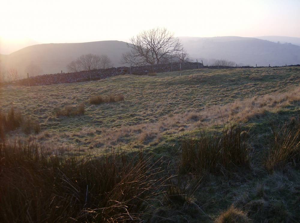
| Location | Downholme Moor. Sidebank. |
| Civil Parish | Downholme |
| Brit. National Grid | SE 1138 9815 |
| Altitude | 250m |
| Geology | Richmond cherts overlying the Main Limestone which forms a scarp at Sidebank and the sheer cliff at White Scar. |
| Record Name | DOW100. Downholme Moor. Sidebank.Linear settlement and associated coaxial field system (DOW101) |
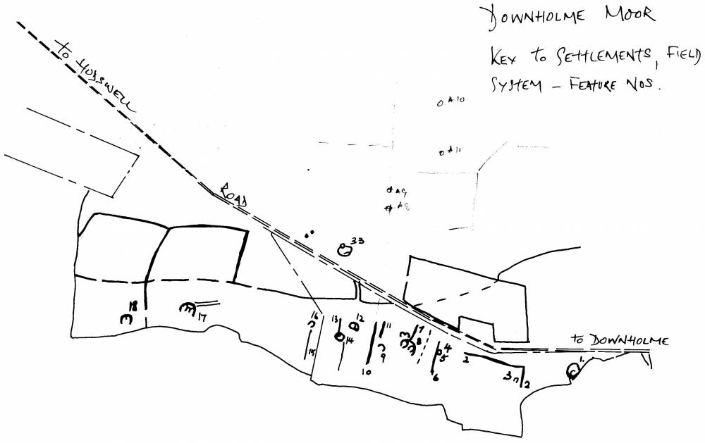
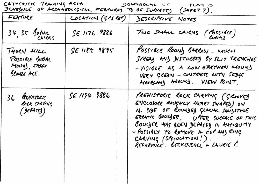
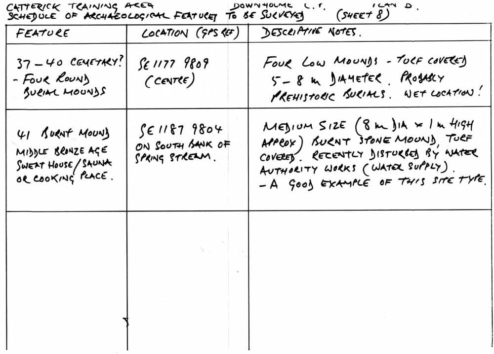
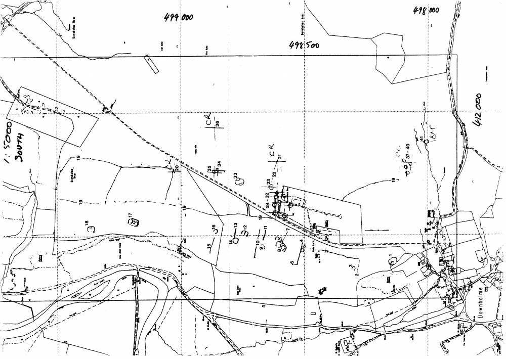
| Record Description | Open linear village type settlement comprising eleven separate homesteads with integral coaxial field system (DOW101). Each feature listed as DOW01-18 and 33 spaced at intervals on the upper slopes of an elevated grassland terrace above the scarp formed by the outcrop of the Main Limestone. The homesteads are associated with coaxial field boundaries which run across the terrace, see DOW101.
A further homestead settlement (Site 33) is located above the unfenced road at SE1173 9875.
Wessex Archaeology Earthwork Survey dated August 2002.
Note! Wessex Survey was based on TCL Walkover Survey Maps, TCL01A,B, Schedule of Sites TCL01C and Site Plans TCL01. The Schedule of Sites, annotated Site Plans TCL01 and Sketched Reconstruction Drawing, EAL1 are provided to assist interpretation of the palimpsest of sites on Downholme Moor.
NOTE! The Wessex Earthwork Survey Maps, Site Plans and Schedule of Sites in their final form are the property of DE and copyright of Wessex Archaeology or NAA – in the ‘grey ‘literature, not readily available to the interested Public.
However, the Wessex Report and Survey is now entered on the YDNP HER and should be accessible.
See also TCL walkover survey map: Location of Sites. TCL Schedule of sites to be surveyed and EAL Sketch Reconstruction of settlements above Sidebank Wood.
From SE1138 9815 to SE1151 9943 |
| Dimensions | See walkover survey plans and photographs |
| Geographical area | |
| Species | |
| Scientific Name | |
| Common / Notable Species | |
| Tree and / or Stem Girth | |
| Tree: Position / Form / Status | |
| Tree Site ID | 0 |
| Associated Site SWAAG ID | 0 |
| Additional Notes | Army Range. Training Area. RESTRICTED ACCESS.
The settlement area can be seen from the permissive footpath which follows the top edge of Sidebank Wood.
This record is the walkover survey completed in advance of a full instrument survey completed by Wessex Archaeology and commissioned by Defence Estates.
Linear settlement and associated coaxial field system (DOW101) (for details of settlements and coaxial field system see listed integral site record sheets)
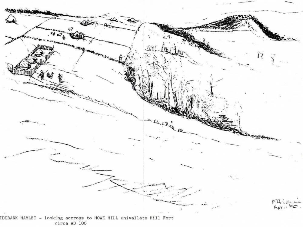
This settlement complex was first recognised by the author and reported to the Catterick and Feldom Conservation Group in April 1990. The whole complex of sites on Downholme Moor was surveyed to modern standards by NAA on behalf of Wessex Archaeology on Commission from Defence Estates in the summer of 2002, (Wessex Archaeology Earthwork Survey, August 2002 Reference 49255,02.).
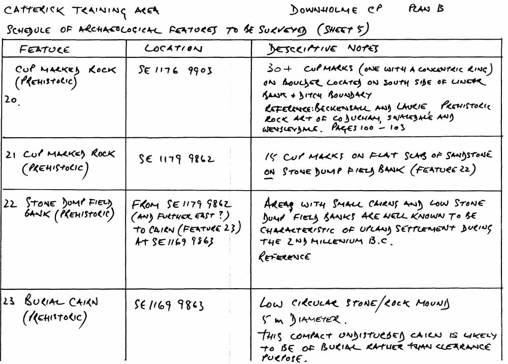
Each of the homesteads, associated field boundaries and the features not directly associated with the settlements, ie of different age comprising areas with small cairns and irregular field banks, a burnt mound, cup marked rocks, later ditched boundaries etc are listed separately as DOW 01.1-. and DOW100-
These Records are based on my own records. The subsequent Earthwork Survey and Gazetteer prepared by Wessex Archaeology for DE shares the same notation. Additional record sheets are numbered DOW100- and additional features recognised and surveyed by NAA on Downholme Moor for Wessex have the prefix A.
Note. In addition, the coaxial field system and all individual settlements, cairns, rock art sites etc above Sidebank Wood and on Downholme Moor each to be recorded seperately on this database. |
| Image 1 ID | 1798 Click image to enlarge |
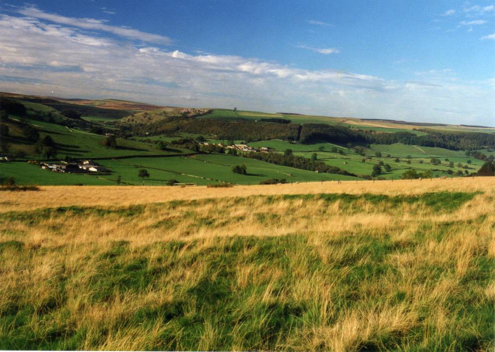
| Image 1 Description | Sidebank from the road from Hudswell. The settlements are on the open terrace above White Scar and on moorland southward from the road. |  |
| Image 2 ID | 1717 Click image to enlarge |
| Image 2 Description | Downeholme Moor. Sidebank and How Hill circa 100BC perhaps. E.A.Laurie Reconstruction. View westward towards How Hill. | 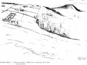 |
| Image 3 ID | 1719 Click image to enlarge |
| Image 3 Description | Location Plan. Site numbering. | 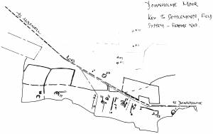 |
| Image 4 ID | 1721 Click image to enlarge |
| Image 4 Description | Schedule of sites including settlements, field boundaries, burial mounds, clearance cairns, rock art, burnt mounds | 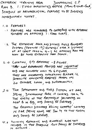 |
| Image 5 ID | 1722 Click image to enlarge |
| Image 5 Description | Schedule continued | 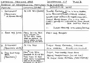 |
| Image 6 ID | 1723 Click image to enlarge |
| Image 6 Description | Schedule continued | 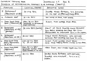 |
| Image 7 ID | 1724 Click image to enlarge |
| Image 7 Description | Schedule continued | 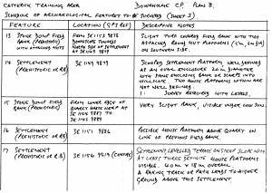 |
| Image 8 ID | 1725 Click image to enlarge |
| Image 8 Description | Schedule continued | 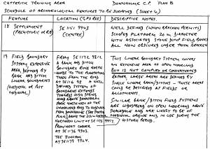 |
| Image 9 ID | 1726 Click image to enlarge |
| Image 9 Description | Schedule continued |  |
| Image 10 ID | 1727 Click image to enlarge |
| Image 10 Description | Schedule continued | 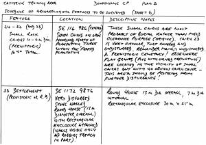 |
| Image 11 ID | 1727 |
| Image 11 Description | | |
| Image 12 ID | 1728 |
| Image 12 Description | |  |
| Image 13 ID | 1729 |
| Image 13 Description | | 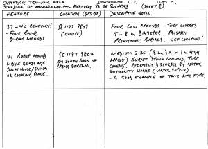 |
| Image 14 ID | 1730 |
| Image 14 Description | | 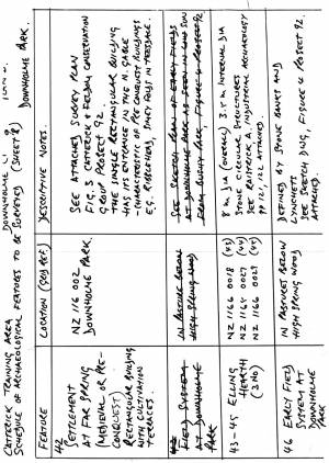 |
| Image 15 ID | 1720 |
| Image 15 Description | Main Plan. Settlements at Sidebank. | 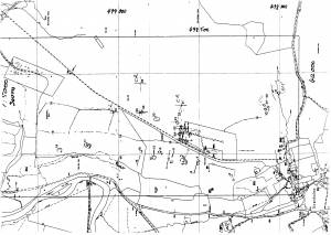 |
| Image 16 ID | 1731 |
| Image 16 Description | Site 1 Enclosed settlement and round house, above Downholme Quarry. How Hill in the background. |  |
| Image 17 ID | 1732 |
| Image 17 Description | Site 1 Enclosed settlement and round house, above Downholme Quarry. |  |
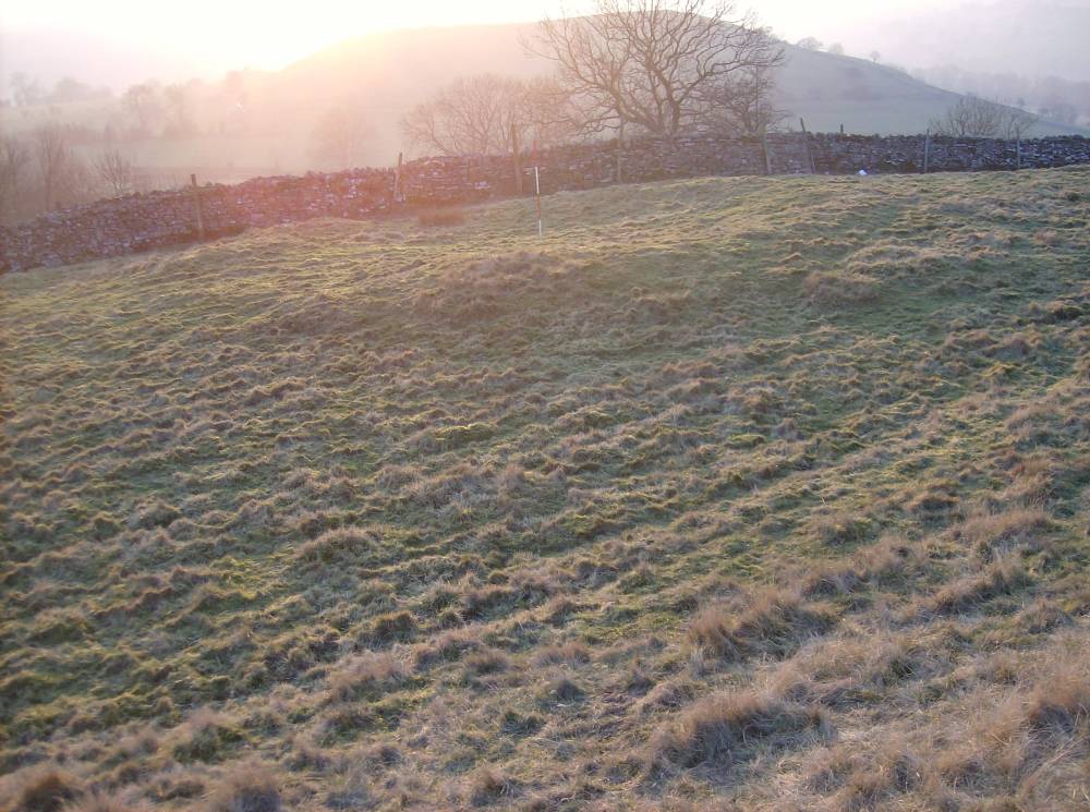
| Image 18 ID | 1734 |
| Image 18 Description | Sidebank. Scooped settlement on terrace (Site No 14 ) and view towards Holgate How in distance. |  |