Close

This site uses cookies. No personal data is stored. You can read how we use them in our cookies policy. Continuing on this site accepts their use. Thankyou.

Viewing swaag.org website implies consent to set cookies on your computer. Full details Swaledale and Arkengarthdale Archaeology Group
Registered Charitable Incorporated Organisation Number 1155775
SWAAG Honorary President:
Tim Laurie F,S,A,

Another Search

Scroll Down the Record
 *****SWAAG_ID***** 430
 Date Entered 17/01/2012
 Updated on 01/09/2012
 Recorded by Ric Carter
 Category Mining Related
 Record Type Mining
 SWAAG Site Name 
 Site Type 
 Site Name 
 Site Description 
 Site Access Public Access Land
 Record Date 17/01/2012
 Location Shaw Beck Gill
 Civil Parish Arkengarthdale
 Brit. National Grid NZ 002 050
 Altitude 347M
 Geology 
 Record Name Shaw Lead Level
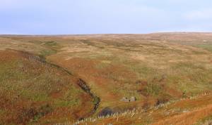
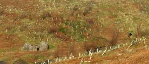
 Record Description Added by S Eastmead: Shaw Level is a Horse Level situated below Stang level and whereas Stang Level was driven to work the below the Main Limestone, Shaw level was driven to work the below the 5 Yard Limestone. According to L.O. Tyson it was plagued with bad air and a number of ventilation shafts where dug. The level ends approximately under Stang Level portal.
 Dimensions 
 Geographical area 
 Species 
 Scientific Name 
 Common / Notable Species 
 Tree and / or Stem Girth 
 Tree: Position / Form / Status 
 Tree Site ID 0
 Associated Site SWAAG ID 0
 Additional Notes 
 Image 1 ID 2094         Click image to enlarge
 Image 1 Description Shaw Lead Level
 Image 2 ID 2095         Click image to enlarge
 Image 2 Description Shaw Lead Level
 Image 3 ID 2136         Click image to enlarge
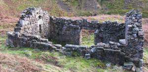
 Image 3 Description close-up of mine buiding
PREV 20PREV 501 502 503 504 505 506 507 508 509 510 511 512 513 514 515 516 517 518 519 520 NEXTNEXT 20
Another Search