|
| *****SWAAG_ID***** | 429 |
| Date Entered | 14/01/2012 |
| Updated on | 03/05/2016 |
| Recorded by | Stephen Eastmead |
| Category | Burial Mounds and Cairns |
| Record Type | Archaeology |
| SWAAG Site Name | |
| Site Type | |
| Site Name | |
| Site Description | |
| Site Access | Army Range |
| Record Date | 14/01/2012 |
| Location | Bellerby Army Ranges. Active. No public access. |
| Civil Parish | Bellerby |
| Brit. National Grid | Hidden |
| Altitude | 313m |
| Geology | Morainic drift over heavily faulted Namurian strata (Ten Fathom Grit and Richmond Cherts) with an outlier of the Preston Moor Coal. The survey area forms the interfluve (watershed) between the Swale (Black Beck) and The Ure (Park Gill). The New range will cut across the line of the natural drainage streams which rise at strongly calcareous, tufa-forming, oncolite rich springs from which clear streams drain and fall through wetland into streams which feed into Park Gill Beck. The morainic hills surround small dry depressions infilled with deep loessic soil where the presence of at least six burnt mounds, small clearance cairns and banks indicate that these areas were recognised during prehistory as providing the opportunity for local cultivation plots (indicating the presence of settlements which have left no surface trace). This Barrow site is located close to the summit of the most prominent of the hills with wide views across the Vale of Mowbray and at close hand, northward towards Park Gill Head. |
| Record Name | Bellerby Deer Park Range. Hengi-Form Barrow with Wessex affinities. |
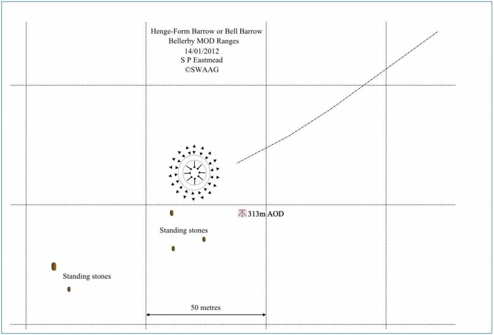
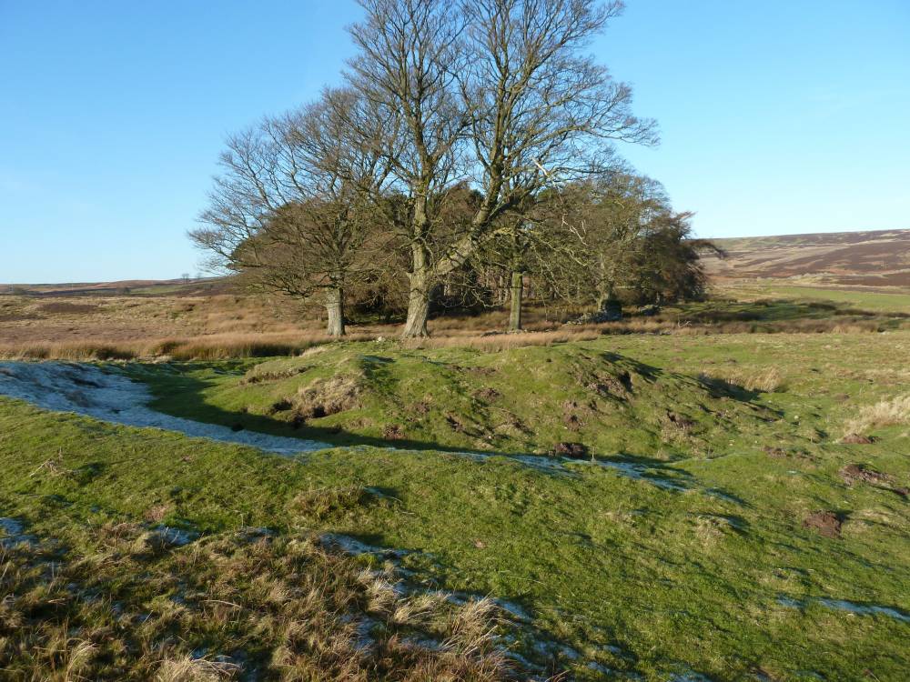
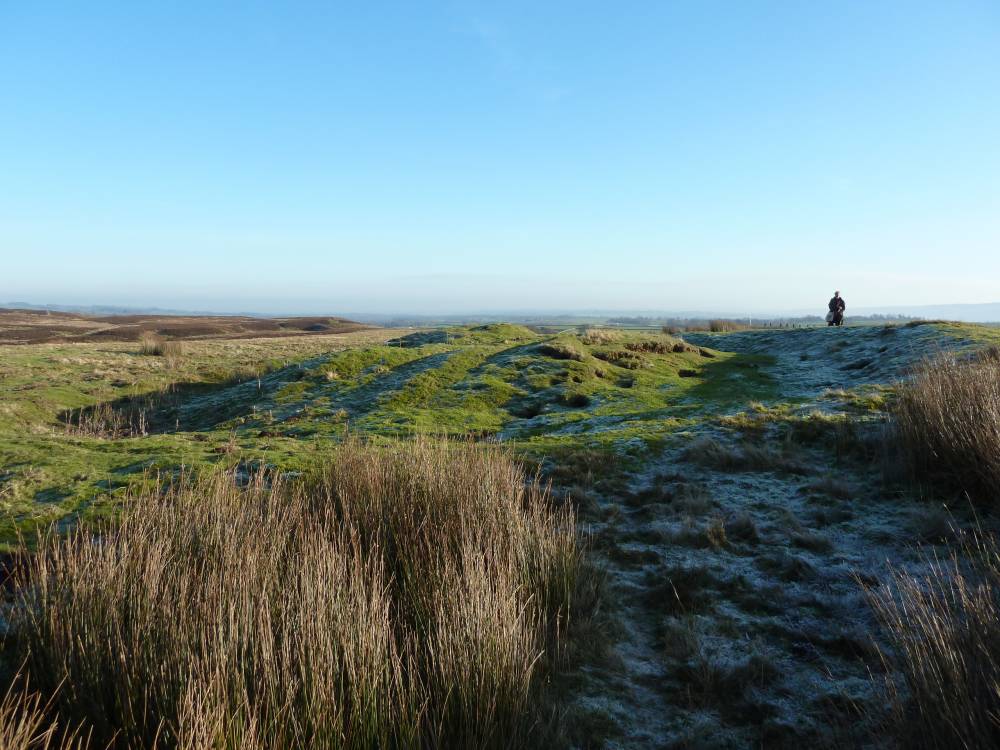
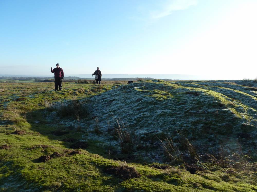
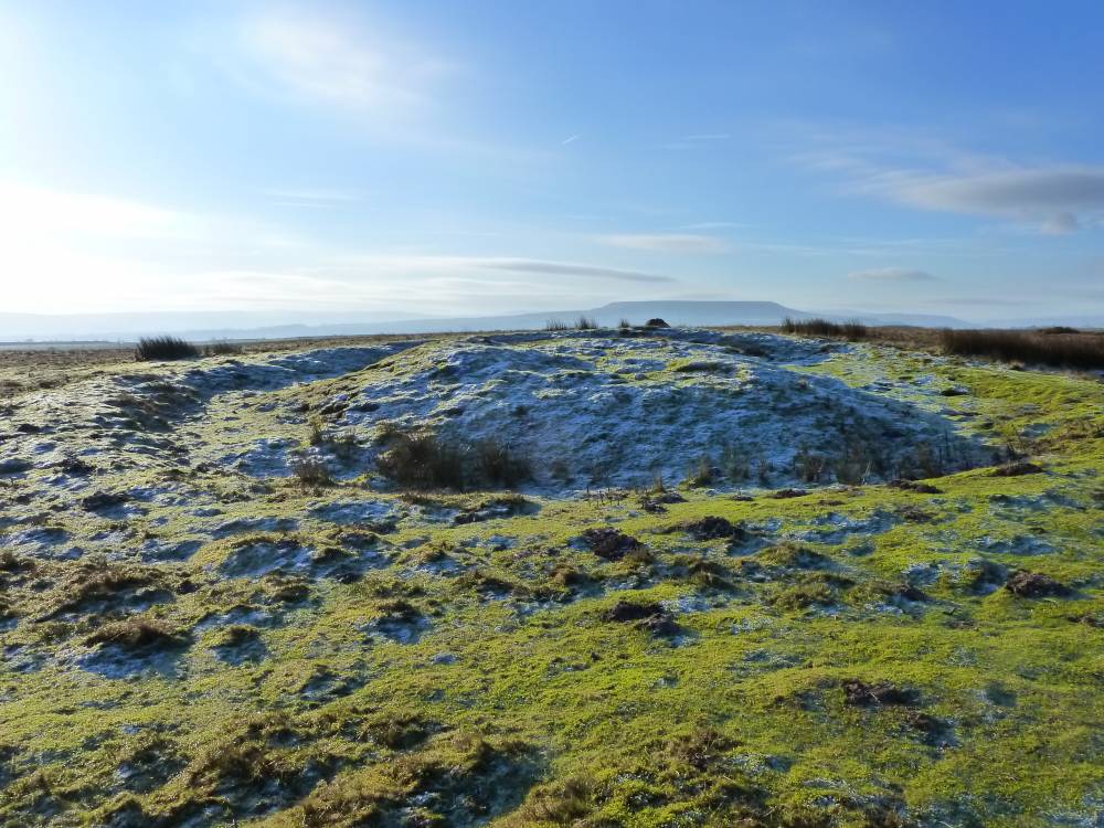
| Record Description | False crested complex Round Barrow comprising 3m high earthern central round barrow with deep, well defined continuous concentric V shaped ditch and a rather low but well defined continuous concentric outer bank. There is no visible berm between barrow and ditch. This hengiform monument is located close to but not quite at the summit and on the eastern side of a low eminence or hill top. It is very near the southern tip of a mature plantation of scots pine. This Barrow was first recognised by SWAAG Members during recent fieldwork in advance of construction of a new small arms range. The general state of survival of this iconic monument is extremely good, considering that it has been overridden by military tracked vehicles.
There are two prominent small standing stones to the west which align with the south east outer bank. There are the stone holes where other stones have been removed. These stones may possibly be the remnant of a circular stone setting. The barrow relates, not to the Wensleydale Lowlands as might be expected but to the area immediately to the north east which is a shallow bowl shaped valley at the head of Park Gill. This shallow valley is noticably sheltered and the presence of a very large burnt mound provides evidence for local perhaps seasonal pastoral settlement possibly contemporary with the Barrow. A further mound of uncertain purpose but which may be a burial mound is located at the centre and at a low point on the floor of the valley about 215m NE of the barrow.
The general area is rough moorland with patches of heather. There are a few small clearance cairns located to the north of the Barrow at areas of deeper loessic soil. There are several other burnt mounds located by calcareous tufa forming springs within 1km to the north of the Barrow, see Survey Maps and Gazetteer. Also leading to the north east from the Barrow is a very shallow earthwork that in places looks like a shallow lynchet, and elsewhere a very shallow track.
A series of measurements were made. The mean readings were: diameter 19.4m, outer bank 2.9m, ditch 2.3m, mound 9.3m. There is significant soil creep down the mound, and erosion due to army vehicles driving through the centre of the barrow. The top of the mound is approximate 3 metres above the ditch.Bell Barrows are classified as rare in the UK. Approximately 250 have been recorded. Considered to be built in the early to middle Bronze Age period.
|
| Dimensions | Diameter between 19-20 metres |
| Geographical area | |
| Species | |
| Scientific Name | |
| Common / Notable Species | |
| Tree and / or Stem Girth | |
| Tree: Position / Form / Status | |
| Tree Site ID | 0 |
| Associated Site SWAAG ID | 0 |
| Additional Notes | Found by: Stephen Eastmead, Gillian Savage and Tim Laurie.
Whereas this barrow bears a superficial resemblance to a Bell Barrow, possibly the most visually impressive form of round barrow,in the absence of excavation no assignation to specific barrow form is possible. Accordingly we shall confine our formal description of this previously unrecorded Monument as a Hengiform Barrow with Wessex Cultural Affinities.
Since the Burial monuments of the Wessex Culture are usually grouped within cemetaries and this barrow is isolated it should be borne in mind this site is one of a number of isolated round stone built cairns (earthern barrows are unusual) on the NE Pennine Fringe and that some 5km to the SW there exists a single entrance henge - Castle Dikes on Flout Moor in Aysgarth Parish. The association of Round Barrows and Ring Cairns with Burnt Mounds (as at Castle Dikes on Flout Moor) is also well attested. (Laurie 2003, 2004).
English Heritage describes the reason for scheduling Bell Barrows as:
Bell barrows, are funerary monuments dating to the Early and Middle Bronze Age, with most examples belonging to the period 1500-1100 BC. They occur either in isolation or in round barrow cemeteries and were constructed as single or multiple mounds covering burials, often in pits, and surrounded by an enclosure ditch. The burials are frequently accompanied by weapons, personal ornaments and pottery and appear to be those of aristocratic individuals, usually men. Bell barrows (particularly multiple barrows) are rare nationally, with less than 250 known examples, most of which are in Wessex. Their richness in terms of grave goods provides evidence for chronological and cultural links amongst early prehistoric communities over most of southern and eastern England as well as providing an insight into their beliefs and social organisation. As a particularly rare form of round barrow, all identified bell barrows would normally be considered to be of national importance.
Other known Late Neolithic/ Bronze Age monuments in Wensleydale include: a single entrance henge (Castle Dikes, Aysgarth),rather few real barrows/cairns, a single free standing stone circle above Thackthwite Springs on Carperby Moor and are a number of ringworks best interpreted as ring cairns. Finally there are a number of non microlithic Lithic Scatters (Later Prehistoric Occupation Sites) and around 90 known Burnt Mounds, see Manby, T.G. 1986 and Laurie, T.C. 2003. It is notable, in support of the association between burnt mounds and hengiform monuments, that there are two very large burnt mounds just 800m west of the Castle Dikes Henge,at Haw Beck Springs on Flout Moor. |
| Image 1 ID | 2090 Click image to enlarge |
| Image 1 Description | Bell Barrow map (no co-ordinates) | 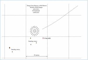 |
| Image 2 ID | 2073 Click image to enlarge |
| Image 2 Description | | 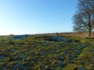 |
| Image 3 ID | 2074 Click image to enlarge |
| Image 3 Description | | 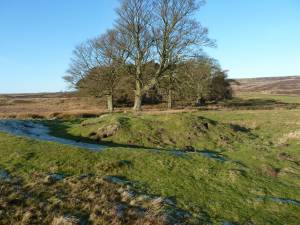 |
| Image 4 ID | 2076 Click image to enlarge |
| Image 4 Description | | 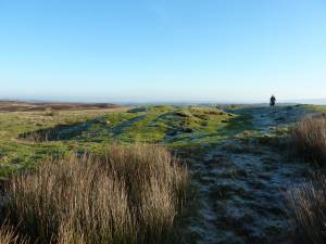 |
| Image 5 ID | 2079 Click image to enlarge |
| Image 5 Description | Image show army vehicle track across the centre of the Bell Barrow. |  |
| Image 6 ID | 2083 Click image to enlarge |
| Image 6 Description | 2 Standing stones. The larger one in the distance is in line with the nearer stone, but is surrounded with sedges. | 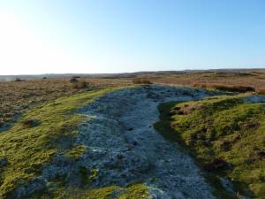 |
| Image 7 ID | 2084 Click image to enlarge |
| Image 7 Description | Photo: Gill Savage. Showing damage caused by Army vehicles. | 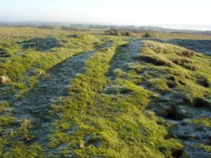 |
| Image 8 ID | 2085 Click image to enlarge |
| Image 8 Description | |  |
| Image 9 ID | 2092 Click image to enlarge |
| Image 9 Description | Bell Barrow map including nearby archaeology (no co-ordinates) | 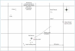 |