Close

This site uses cookies. No personal data is stored. You can read how we use them in our cookies policy. Continuing on this site accepts their use. Thankyou.

Viewing swaag.org website implies consent to set cookies on your computer. Full details Swaledale and Arkengarthdale Archaeology Group
Registered Charitable Incorporated Organisation Number 1155775
SWAAG Honorary President:
Tim Laurie F,S,A,

Another Search

Scroll Down the Record
 *****SWAAG_ID***** 458
 Date Entered 17/02/2012
 Updated on 17/02/2012
 Recorded by Ric Carter
 Category Burial Mounds and Cairns
 Record Type Archaeology
 SWAAG Site Name 
 Site Type 
 Site Name 
 Site Description 
 Site Access Public Access Land
 Record Date 16/02/2012
 Location Brownsey Moor
 Civil Parish Melbecks
 Brit. National Grid SD 96869 98791
 Altitude 
 Geology 
 Record Name Stone Setting
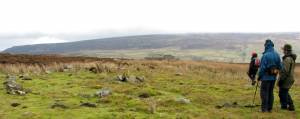
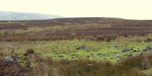
 Record Description A well defined, ovoid, stone setting approx 20m x 10m with central cairn and two short lengths of walling. Associated with the moorland field system, of probable funerary purpose and attributed to the late Bronze Age/ early Iron age periods. The site is immediately below the much later mine level and spoil heap.
 Dimensions as above
 Geographical area 
 Species 
 Scientific Name 
 Common / Notable Species 
 Tree and / or Stem Girth 
 Tree: Position / Form / Status 
 Tree Site ID 0
 Associated Site SWAAG ID 0
 Additional Notes 
 Image 1 ID 2282         Click image to enlarge
 Image 1 Description Brownsey Moor Stone Setting
 Image 2 ID 2283         Click image to enlarge
 Image 2 Description Brownsey Moos Stone Setting
PREV 20PREV 481 482 483 484 485 486 487 488 489 490 491 492 493 494 495 496 497 498 499 500 NEXTNEXT 20
Another Search