Close

This site uses cookies. No personal data is stored. You can read how we use them in our cookies policy. Continuing on this site accepts their use. Thankyou.

Viewing swaag.org website implies consent to set cookies on your computer. Full details Swaledale and Arkengarthdale Archaeology Group
Registered Charitable Incorporated Organisation Number 1155775
SWAAG Honorary President:
Tim Laurie FSA

Another Search

Scroll Down the Record
 *****SWAAG_ID***** 829
 Date Entered 12/08/2014
 Updated on 12/08/2014
 Recorded by Ric Carter
 Category Lithic Find / Scatter
 Record Type Archaeology
 SWAAG Site Name 
 Site Type 
 Site Name 
 Site Description 
 Site Access Public Access Land
 Record Date 29/07/2014
 Location Between Calver Hill and Cringley Hill near to Bale Sites above disused quarry
 Civil Parish Reeth
 Brit. National Grid NZ 00325 00396
 Altitude 432m
 Geology 
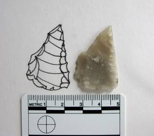
 Record Name Flint Point - stray find
 Record Description A fine, unpatinated,transluscent grey/white flint point with oblique retouch identified by Tim Laurie as a small knife or scoring tool and attributed to the late Neolithic/early Bronze Age.
 Dimensions 35mm x 25mm
 Geographical area 
 Species 
 Scientific Name 
 Common / Notable Species 
 Tree and / or Stem Girth 
 Tree: Position / Form / Status 
 Tree Site ID 0
 Associated Site SWAAG ID 0
 Additional Notes 
 Image 1 ID 5756         Click image to enlarge
 Image 1 Description Flint Point
PREV 20PREV 141 142 143 144 145 146 147 148 149 150 151 152 153 154 155 156 157 158 159 160 NEXTNEXT 20
Another Search