|
| *****SWAAG_ID***** | 134 |
| Date Entered | 18/02/2011 |
| Updated on | 18/02/2011 |
| Recorded by | Tim Laurie |
| Category | Rock Art |
| Record Type | Archaeology |
| SWAAG Site Name | |
| Site Type | |
| Site Name | |
| Site Description | |
| Site Access | Public Access Land |
| Record Date | 31/10/2006 |
| Location | Marske CP. Forty Acres Allotment. |
| Civil Parish | Not known |
| Brit. National Grid | Hidden |
| Altitude | 305m |
| Geology | Earthfast erratic block of fell sandstone on moraine. |
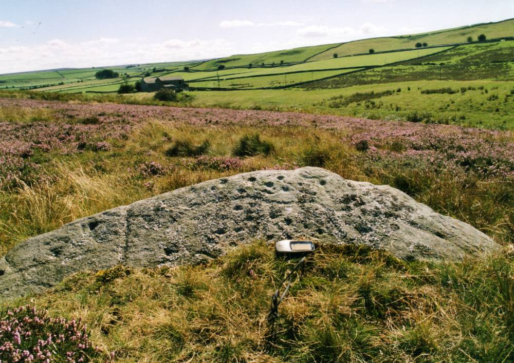
| Record Name | Marske CP. Forty Acres Allotment. Cup and ring marked rock east of Dales Beck. |
| Record Description | This rock is among the most recent to have been found on the extensive moorland allotments above Marske which can collectively be named Skelton Moor.The cup and ring marked rock in pasture on the West side of Dales Beck is just 200m to the NW at Stelling in Marrick CP (Beckensall and Laurie 1998, Figured on page 96).
No less than seven burnt mounds are situated at Stelling Springs with four 500m to the West and a further burnt mound is located at Dales Beck, 500m to the North West.
A hut circle settlement is located slightly higher up the hillside some 200m to the North of this cup marked rock.
en this earthfast decorated rock was first recognised during 2006, just the upper section was exposed, the major part of the rock was buried under turf. A large number of very small cupmarks with a wandering groove, very characteristic of cup and ring marked rocks,could be seen on the exposed surface of the rock, see photograph.
At a subsequent date this rock was independently recognised and the whole rock excavated to reveal extremely complex carved figures. A photograph of the whole of the excavated rock appeared in Current Archaeology, 241, April 2010.
|
| Dimensions | |
| Geographical area | |
| Species | |
| Scientific Name | |
| Common / Notable Species | |
| Tree and / or Stem Girth | |
| Tree: Position / Form / Status | |
| Tree Site ID | 0 |
| Associated Site SWAAG ID | 0 |
| Additional Notes | The presence of rock art in enclosed pasture west of Dales Beck and on the moorland of Cock How, and on Skelton Moor in Marske Parish was first recognised in the early 1980's (Laurie 1985) during the initial survey of the coaxial field systems which extend from Fremington Edge to Mun End above Marske Beck.
|
| Image 1 ID | 314 Click image to enlarge |
| Image 1 Description | Cup and ring marked rock east of Dales Beck. |  |