|
| *****SWAAG_ID***** | 137 |
| Date Entered | 21/02/2011 |
| Updated on | 21/02/2011 |
| Recorded by | Tim Laurie |
| Category | Burnt Mound |
| Record Type | Archaeology |
| SWAAG Site Name | |
| Site Type | |
| Site Name | |
| Site Description | |
| Site Access | Public Access Land |
| Record Date | 01/01/2005 |
| Location | West Burton CP. Burnt mound in pasture below Ashby Gill. Site 2 |
| Civil Parish | Not known |
| Brit. National Grid | |
| Altitude | |
| Geology | |
| Record Name | Burnt Mound in pasture below Ashby Gill Site 2 |
| Record Description | Medium size burnt mound by small sike, now diverted to duck flight pond. |
| Dimensions | 8m Diameter and .7m high above present ground level. Estimated |
| Geographical area | |
| Species | |
| Scientific Name | |
| Common / Notable Species | |
| Tree and / or Stem Girth | |
| Tree: Position / Form / Status | |
| Tree Site ID | 0 |
| Associated Site SWAAG ID | 0 |
| Additional Notes | This is the second and middle bm site of three burnt mounds located on this now diverted stream.
Coaxial field system and enclosures which may be settlement nuclei nearby. |
| Image 1 ID | 339 Click image to enlarge |
| Image 1 Description | Below Ashby Gill, Burnt Mound Site 2, view towards Site 1. | 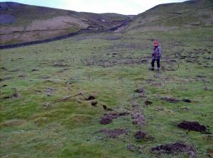 |
