|
| *****SWAAG_ID***** | 622 |
| Date Entered | 20/10/2012 |
| Updated on | 22/10/2012 |
| Recorded by | Tim Laurie |
| Category | Burnt Mound |
| Record Type | Archaeology |
| SWAAG Site Name | |
| Site Type | |
| Site Name | |
| Site Description | |
| Site Access | Private |
| Record Date | 01/01/2005 |
| Location | Askrigg Pasture, High Straights lane |
| Civil Parish | Askrigg |
| Brit. National Grid | SD 94372 92326 |
| Altitude | 373m |
| Geology | Drift over Middle Limestone |
| Record Name | Akrigg Pasture Burnt Mound Site 3. |
| Record Description | This medium burnt mound, is located in rushy marsh and is 7m diameter and 1m high approximately. This site is the third of an open cluster of four burnt mounds situated in Askrigg Pastures above and below the western end of High Straights Lane. |
| Dimensions | 7m diameter and 1m high |
| Geographical area | |
| Species | |
| Scientific Name | |
| Common / Notable Species | |
| Tree and / or Stem Girth | |
| Tree: Position / Form / Status | |
| Tree Site ID | 0 |
| Associated Site SWAAG ID | 0 |
| Additional Notes | First reported by Laurie T.C., 2004. 'Burnt Mounds in Wensleydale and Swaledale.' in R.F. White and P.R.Wilson Eds. Archaeology and Historic Landscapes of the Yorkshire Dales. For details of the landscape setting of this site, see photographs. |
| Image 1 ID | 3489 Click image to enlarge |
| Image 1 Description | Askrigg Pasture Burnt Mound No 3. | 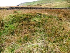 |
