|
| *****SWAAG_ID***** | 617 |
| Date Entered | 08/10/2012 |
| Updated on | 08/10/2012 |
| Recorded by | Tim Laurie |
| Category | Geological Record |
| Record Type | Geological HER |
| SWAAG Site Name | |
| Site Type | |
| Site Name | |
| Site Description | |
| Site Access | Public Access Land |
| Record Date | 04/10/2012 |
| Location | Muker Common. Noon Gill. |
| Civil Parish | Stainton |
| Brit. National Grid | SD 8940 9645 |
| Altitude | 530m |
| Geology | Stream cut ravine revealing black shales or mudstone strata with thin interbedded calcareous sandstone beds of Late Pendleian and Arngillian (Namurian) Age. (Dunham and Wilson 1985,p166).
The photographs show the sandstone beds dip sharply down close to the junction with horizontal beds of the Main Limestone indicating that the stream has respected a minor fault in the Providence Vein series of fractures. |
| Record Name | Noon Gill Head. A stream cut ravine through black shales above the Main Limestone. |
| Record Description | Stream cut ravine at the western end of West Greenseat in black shales or mudstones with thin interbedded calcareous sandstone beds of Late Pendleian and Arngillian (Namurian) Age. (Dunham and Wilson 1985,p166).
The photographs show the sandstone beds dip sharply down close to the junction with horizontal beds of the Main Limestone indicating that the stream has respected a minor fault in the Providence Vein series of fractures.
The Tan Hill Coal outcrops at a higher elevation. |
| Dimensions | |
| Geographical area | |
| Species | |
| Scientific Name | |
| Common / Notable Species | |
| Tree and / or Stem Girth | |
| Tree: Position / Form / Status | |
| Tree Site ID | 0 |
| Associated Site SWAAG ID | 0 |
| Additional Notes | |
| Image 1 ID | 3448 Click image to enlarge |
| Image 1 Description | Noon Gill. Ravine cut through black shales above the Main Limestone. | 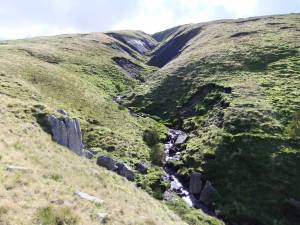 |
| Image 2 ID | 3449 Click image to enlarge |
| Image 2 Description | Noon Gill detail showing strata dipping at minor fault close to junction with the Main Limestone | 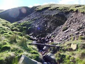 |
| Image 3 ID | 3450 Click image to enlarge |
| Image 3 Description | Noon Gill detail showing strata dipping at minor fault close to junction with the Main Limestone | 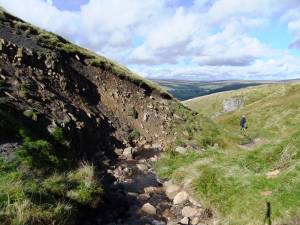 |
| Image 4 ID | 3451 Click image to enlarge |
| Image 4 Description | West Greenseat. Line of solution holes mark the outcrop of the Main Limestone east of Noon Gill. | 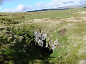 |


