|
| *****SWAAG_ID***** | 572 |
| Date Entered | 02/07/2012 |
| Updated on | 02/07/2012 |
| Recorded by | Ric Carter |
| Category | Burnt Mound |
| Record Type | Archaeology |
| SWAAG Site Name | |
| Site Type | |
| Site Name | |
| Site Description | |
| Site Access | Public Footpath |
| Record Date | 01/07/2012 |
| Location | Above Hags Gill Plantation, Ellerton Moor. |
| Civil Parish | Ellerton Abbey |
| Brit. National Grid | SE 06650 96661 |
| Altitude | 880 ft. |
| Geology | |
| Record Name | Burnt Mound above Hags Gill plantation |
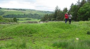
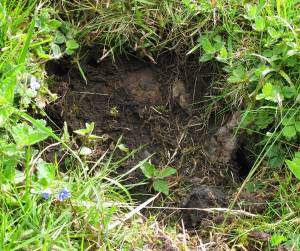
| Record Description | Large Burnt Mound above Hags Gill Plantation, on private land but visible from Public Footpath; burnt stone visible in eroded bank; alongside low volume watercourse. |
| Dimensions | Approx 12m x 7m x 1.7m high (paced) |
| Geographical area | |
| Species | |
| Scientific Name | |
| Common / Notable Species | |
| Tree and / or Stem Girth | |
| Tree: Position / Form / Status | |
| Tree Site ID | 0 |
| Associated Site SWAAG ID | 0 |
| Additional Notes | |
| Image 1 ID | 3145 Click image to enlarge |
| Image 1 Description | Burnt Mound above Hags Gill Plantation, with Alex Loktionov and Mike Walton |  |
| Image 2 ID | 3146 Click image to enlarge |
| Image 2 Description | Burnt Mound above Hags Gill Plantation - detail of burnt stone in eroded bank. |  |

