Close

This site uses cookies. No personal data is stored. You can read how we use them in our cookies policy. Continuing on this site accepts their use. Thankyou.

Viewing swaag.org website implies consent to set cookies on your computer. Full details Swaledale and Arkengarthdale Archaeology Group
Registered Charitable Incorporated Organisation Number 1155775
SWAAG Honorary President:
Tim Laurie FSA

Another Search

Scroll Down the Record
 *****SWAAG_ID***** 565
 Date Entered 02/07/2012
 Updated on 02/02/2014
 Recorded by Ric Carter
 Category Rock Art
 Record Type Archaeology
 SWAAG Site Name 
 Site Type 
 Site Name 
 Site Description 
 Site Access Public Access Land
 Record Date 15/06/2012
 Location Munn End, Skelton Moor
 Civil Parish Marske
 Brit. National Grid Hidden
 Altitude 346m
 Geology 
 Record Name Rock Art
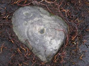
 Record Description This small, portable, cup-and-ring marked rock was first recorded by T.C. Laurie a number of years ago ( see SWAAG database record 365; image 1474 ) but subsequently lost under thick heather. Recently re-recorded ( at same location) now heather burnt off.
 Dimensions visible surface approx. 45cm x 35 cm
 Geographical area 
 Species 
 Scientific Name 
 Common / Notable Species 
 Tree and / or Stem Girth 
 Tree: Position / Form / Status 
 Tree Site ID 0
 Associated Site SWAAG ID 0
 Additional Notes 
 Image 1 ID 3142         Click image to enlarge
 Image 1 Description portable cup-and-ring marked rock re-recorded at Munn End.
PREV 20PREV 381 382 383 384 385 386 387 388 389 390 391 392 393 394 395 396 397 398 399 400 NEXTNEXT 20
Another Search