|
| *****SWAAG_ID***** | 564 |
| Date Entered | 02/07/2012 |
| Updated on | 29/08/2012 |
| Recorded by | Will Swales |
| Category | Vernacular Record |
| Record Type | General HER |
| SWAAG Site Name | |
| Site Type | |
| Site Name | |
| Site Description | |
| Site Access | Public Access Land |
| Record Date | 02/07/2012 |
| Location | 120m NW of Height of Brownseat |
| Civil Parish | Grinton |
| Brit. National Grid | SE 049 949 |
| Altitude | 460m |
| Geology | |
| Record Name | Boundary stone 120m NW of Height of Brownseat |
| Record Description | GRI-15 is not marked on the OS map. It is boundary stone number 15 of the first 21 around Grinton Parish starting from Stolerston Stile and reaching as far as Gibbon Hill. It stands on the Grinton-Bolton watershed, on the Grinton side of a boundary wall. I’m grateful to Tim Gates for supplying a transcript of documentary evidence at The National Archives (E112/765 Ebor 189A) to show that this stone was erected in 1663 to determine the boundary between the estates of Sir Solomon Swale 1st baronet to the north and of Charles Paulet, who styled himself Charles, Lord St John, to the south. See also records 561, 562 and 563. The stone is one of three in the series depicting the coats of arms of the two men on its north and south faces. This one is by far the best preserved. Paulet had married the heiress to the Bolton estates and would later become the 1st Duke of Bolton |
| Dimensions | |
| Geographical area | |
| Species | |
| Scientific Name | |
| Common / Notable Species | |
| Tree and / or Stem Girth | |
| Tree: Position / Form / Status | |
| Tree Site ID | 0 |
| Associated Site SWAAG ID | 0 |
| Additional Notes | On the north face of this stone is a blazon divided vertically, two-thirds and a third, combining the two coats of arms of Swale. In the larger right-hand portion are the three harts’ heads associated with Swale of Swale Hall, and on the left is the ‘bend nebulee’ (a wavy, diagonal band) associated with Swale of South Stainley, near Ripon, which was the baronet’s ancestral home. He had united the two estates when he purchased the lands of Swale Hall from his kinsman ‘old’ Solomon Swale in 1649. This stone and two others in this short series bear the only known depictions of these arms combined; the combination apparently defying the rules of heraldry. On the south face of the stone is another split blazon, this one showing the combined arms of Charles Paulet – three swords – and his wife Mary le Scrope – a simple ‘bend’ (straight-sided diagonal band). In this case the combination is an accepted convention to signify the marriage of two holders of arms. |
| Image 1 ID | 3132 Click image to enlarge |
| Image 1 Description | Grinton-Bolton boundary stone 120m NW of Height of Brownseat – north face | 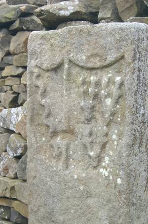 |
