|
| *****SWAAG_ID***** | 585 |
| Date Entered | 28/07/2012 |
| Updated on | 28/07/2012 |
| Recorded by | Tim Laurie |
| Category | Mining Related |
| Record Type | Mining |
| SWAAG Site Name | |
| Site Type | |
| Site Name | |
| Site Description | |
| Site Access | Public Access Land |
| Record Date | 01/01/2005 |
| Location | Arkengarthdale. Tanner Rake, Scatter Scar and North Rake Hushes from Fell End. |
| Civil Parish | Arkengarthdale |
| Brit. National Grid | NZ 020 024 |
| Altitude | 400m |
| Geology | The Main Limestone. Lead mining on mineralised faults. |
| Record Name | Arkengarthdale. Sleigill. Tanner Rake, Scatter Scar and North Rake Hushes from Fell End. |
| Record Description | Open cast lead mining hushes and levels on the Great Blackside Vein.
For the history and details of the lead mines here, see Len Tyson's excellent Monograph: 'The Arkengarthdale Mines.' British Mining No 53. August 1995. |
| Dimensions | |
| Geographical area | |
| Species | |
| Scientific Name | |
| Common / Notable Species | |
| Tree and / or Stem Girth | |
| Tree: Position / Form / Status | |
| Tree Site ID | 0 |
| Associated Site SWAAG ID | 0 |
| Additional Notes | |
| Image 1 ID | 3186 Click image to enlarge |
| Image 1 Description | Tanner Rake, Scatter Scar and North Rake Hushes from Fell End. | 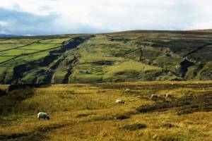 |
