|
| *****SWAAG_ID***** | 3 |
| Date Entered | 09/01/2011 |
| Updated on | 02/02/2012 |
| Recorded by | Tim Laurie |
| Category | Burnt Mound |
| Record Type | Archaeology |
| SWAAG Site Name | |
| Site Type | |
| Site Name | |
| Site Description | |
| Site Access | Army Range |
| Record Date | 01/01/2011 |
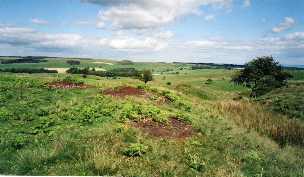
| Location | Three burnt mounds located on the banks of a small sike above the North Side of Spring Gill, Site 1 |
| Civil Parish | Walburn |
| Brit. National Grid | SE 1097 9477 |
| Altitude | 280m |
| Geology | Glacial till over Crow Cherts. |
| Record Name | Walburn CP. Three Burnt Mounds above Spring Gill. Burnt Mound Sites 1-3. First recorded by Tim Laurie |
| Record Description | Army Firing Range.
Brief description of the three burnt mounds:
Site 1. The largest of the three burnt mounds at this location. Prominant.Easily recognised from the adjacent vehicle track.
Prominent crescent shaped burnt mound 10m*9m*.7m high. Much of the burnt stone core has been removed by erosion of the bracken peat and turf cover. Unusually, the central trough area does not face the water source (sike). This may imply activity on the level area west of this mound.
Site 2
Very small site located just 3m upslope from Site 1.
Site 3
Medium site located on the southern side of the small sike (stream) immediately opposite Site 1.
NOTE!
DANGER Area!
This site is within a live army firing range and access is NOT permitted without express written permission from the Range Authorities. |
| Dimensions | Site 1. Large, average Site 2 Small, low. Site 3 Medium low.* |
| Geographical area | |
| Species | |
| Scientific Name | |
| Common / Notable Species | |
| Tree and / or Stem Girth | |
| Tree: Position / Form / Status | |
| Tree Site ID | 0 |
| Associated Site SWAAG ID | 0 |
| Additional Notes | *Indicative Dimensions:
Size: Small <6m, Medium 6m-9m, Large 10m-15m, Extra large >15m.
Height: Low <0.5m, Average 0.5-1.0m, High >1.0m.
Elevated vantage point location.
Burnt mounds are crescentic or circular mounds of fire cracked , reddened sandstone. They vary in size from 4m to 18m diameter and can be more than 2m above present ground level.
In the Eastern Dales, their regular distribution at springs at 1-2km intervals on the Dale Sides may represent the distribution of contemporary transient settlements with which they were associated.
They are numerous throughout Britain and their distribution is not limited to the Uplands. Their use as sweat house saunas seems most probable in the absence of any evidence for cooking. Radiocarbon dates from burnt mounds have been obtained from as early as 2400CalBC to around 800 CalBC, most are of Middle Bronze Age date.
References
Laurie,T.C. 2003. Researching the Prehistory of Wensleydale, Swaledale and Teesdale, in ‘The Archaeology of Yorkshire-an assessment at the beginning of the twenty first century’. Leeds: Y.A.Soc Occ Pap 3, 223-34.
Laurie , T.C. 2004. ‘Burnt mounds in Wensleydale and Swaledale’. Leeds: Y.A.Soc Occ Pap 2,79-88.
Laurie,T.C 2007 ‘ Enigma excavations - The Sturdy Springs Burnt Mounds, October 2006’.Conservation Update. Defense Estates.
|
| Image 1 ID | 413 Click image to enlarge |
| Image 1 Description | Walburn CP. Spring Gill. Three burnt mounds. Location plan. | 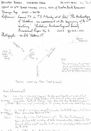 |
| Image 2 ID | 414 Click image to enlarge |
| Image 2 Description | Walburn CP. Spring Gill. Burnt mounds Sites 1(The larger site) and 2 (very small site), Site 3 is on the other bank of the small stream opposite Site 1 (The larger Site).. |  |