|
| *****SWAAG_ID***** | 8 | | Date Entered | 09/01/2011 | | Updated on | 02/02/2012 | | Recorded by | Tim Laurie | | Category | Burnt Mound | | Record Type | Archaeology | | SWAAG Site Name | | | Site Type | | | Site Name | | | Site Description | | | Site Access | Army Range | | Location | Stainton Moor, The White Bog. | | Civil Parish | Stainton | | Brit. National Grid | SE 090 955 | | Altitude | 300m | | Geology | | | Record Name | Stainton Moor. Large Burnt Mound at the White Bog. | | Record Description | In marsh, see survey plan of White Bog field system and cairnfield in Fleming, 1999, Figure 8.3.
See introduction to Burnt Mounds for a general description of these sites. Burnt mounds are frequently located in close association with cairnfield type settlements of mid bronze age character.
This burnt mound, located in a marsh at thew spring head, is upper of two burnt mounds on the White Bog Stream. These burnt mounds are a component in the fossil Bronze age Landscape (STA03) on north side of the White Bog stream. This landscape comprises a field system, numbers of clearance cairns, the two burnt mounds and a circular enclosure which may be a simple stock enclosure, a round house or ring cairn. The prominent mound south of Stainton Moor Beck at SExxxxxx is probably glacial in origin, but this mound is recorded as a possible round barrow or burial mound.
This fossil landscape was surveyed within the Swaledale Ancient Land Boundaries Project (SALB Project Ninth Interim Report, 1992), see Figure 01 (STA03.01).
Reference:
Fleming, A. 1998 Fig 8.3
NOTE!
DANGER AREA!
THis is a n Army Range LIve Firing Range. Access is NOT permitted without express written permission from the Range Authorities. | | Dimensions | Large, high | | Geographical area | | | Species | | | Scientific Name | | | Common / Notable Species | | | Tree and / or Stem Girth | | | Tree: Position / Form / Status | | | Tree Site ID | 0 | | Associated Site SWAAG ID | 0 | | Additional Notes | Dimensions.
Size: Small <6m, Medium 6m-9m, Large 10m-15m, Extra large >15m.
Height: Low <0.5m, Average 0.5-1.0m, High >1.0m.
Burnt mounds are crescentic or circular mounds of fire cracked , reddened sandstone. They vary in size from 4m to 18m diameter and can be more than 2m above present ground level.
In the Eastern Dales, their regular distribution at springs at 1-2km intervals on the Dale Sides may represent the distribution of contemporary transient settlements with which they were associated.
They are numerous throughout Britain and their distribution is not limited to the Uplands. Their use as sweat house saunas seems most probable in the absence of any evidence for cooking. Radiocarbon dates from burnt mounds have been obtained from as early as 2400CalBC to around 800 CalBC, most are of Middle Bronze Age date.
The six burnt mounds at the spring line overlooking Harker Mires of which this is the largest, are an important component in the Bronze Age landscape complex centred on the ring cairn and cairnfield (Grinton 2650) 150m to the North of this site. They may be the earliest evidence for transient seasonal occupation of this well watered elevated terrace. The small low energy stream would have provided ideal habitat for beaver whose silted up dams (Bryony Coles, 2006) may have caused the formation of fertile mesa pastures attractive to fauna and most suitable to pioneering arable settlement- such as the the cairnfield and paddock like fields on Harker Mires.
Many burnt mounds throughout the Dales are located at the spring rise of lateral, low energy streams which flow parallel to and across the elevated terrace below the Underset Limestone before turning at right angle to fall abruptly to the floor of the dale below.
References
Coles, Bryony. 2006. Beavers in Britain�s Past. Oxbow.
Laurie,T.C. 2003. Researching the Prehistory of Wensleydale, Swaledale and Teesdale, in �The Archaeology of Yorkshire-an assessment at the beginning of the twenty first century�. Leeds: Y.A.Soc Occ Pap 3, 223-34.
Laurie , T.C. 2004. �Burnt mounds in Wensleydale and Swaledale�. Leeds: Y.A.Soc Occ Pap 2,79-88.
Laurie, T.C 2007. � Enigma excavations - The Sturdy Springs Burnt Mounds, October 2006�. Conservation Update, Defense Estates. 2007.
| | Image 1 ID | 412 Click image to enlarge | | Image 1 Description | The White Bog cairnfield, field system, settlements and two burnt mounds. SWALB Survey Plan. | 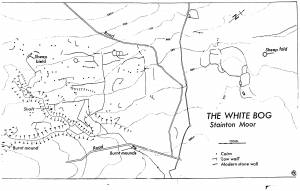 | |
