|
| *****SWAAG_ID***** | 7 | | Date Entered | 09/01/2011 | | Updated on | 14/12/2011 | | Recorded by | Tim Laurie | | Category | Burnt Mound | | Record Type | Archaeology | | SWAAG Site Name | | | Site Type | | | Site Name | | | Site Description | | | Site Access | Army Range | | Location | Stainton Moor, The White Bog. | | Civil Parish | Stainton | | Brit. National Grid | SE 094 958 | | Altitude | 260m | | Geology | | | Record Name | Stainton Moor. The White Bog. Burnt Mound Lower Site. | | Record Description | Large complex burnt mound located at north bank of stream and very close to an army access road.
Part quarried for adjacent track.
This burnt mound is the lower of two burnt mounds which are located in the vicinity of an unenclosed cairnfield settlement.
These two burnt mounds at the White Bog illustrate the very frequent association on the NE Pennine Fringe of burnt mound sites with settlements of mid Bronze Age Character.
See introduction to Burnt Mounds for a general description of these sites.
The two burnt mounds are a component in the fossil Bronze age Landscape (STA03) on north side of the White Bog stream. This landscape comprises a field system, numbers of clearance cairns, the two burnt mounds and a circular enclosure which may be a simple stock enclosure, a round house or ring cairn. The prominent mound south of Stainton Moor Beck at SExxxxxx is probably glacial in origin, but this mound is recorded as a possible round barrow or burial mound.
This fossil landscape was surveyed within the Swaledale Ancient Land Boundaries Project (SALB Project Ninth Interim Report, 1992), see Figure 01 (STA03.01).
Reference:
Fleming, A. 1998 Fig 8.3
NOTE!
DANGER Area!
This site is within a live army firing range and access is NOT permitted without express written permission from the Range Authorities. | | Dimensions | Large, high | | Geographical area | | | Species | | | Scientific Name | | | Common / Notable Species | | | Tree and / or Stem Girth | | | Tree: Position / Form / Status | | | Tree Site ID | 0 | | Associated Site SWAAG ID | 0 | | Additional Notes | Dimensions.
Size: Small <6m, Medium 6m-9m, Large 10m-15m, Extra large >15m.
Height: Low <0.5m, Average 0.5-1.0m, High >1.0m. | | Image 1 ID | 412 Click image to enlarge | | Image 1 Description | The White Bog cairnfield, field system, settlements and two burnt mounds. SWALB Survey Plan. | 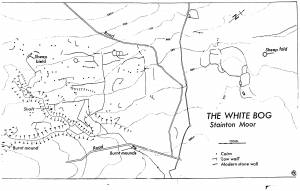 | |
