|
| *****SWAAG_ID***** | 557 | | Date Entered | 30/06/2012 | | Updated on | 30/07/2012 | | Recorded by | Will Swales | | Category | Vernacular Record | | Record Type | General HER | | SWAAG Site Name | | | Site Type | | | Site Name | | | Site Description | | | Site Access | Public Access Land | | Record Date | 30/06/2012 | | Location | Stolerston Stile | | Civil Parish | Grinton | | Brit. National Grid | SE 059 976 | | Altitude | 215m | | Geology | | | Record Name | Road to Stolerston Stile | | Record Description | View eastwards into Ellerton Parish from the boundary stone of Stolerston Stile. Are the visible stones the remains of the old road from Richmond? In his book Swaledale: Valley of the Wild River, Andrew Fleming says (p105) that this old road ran from the gate of Ellerton nunnery, along the main street of the now-deserted Ellerton village, past Swale Farm, south of Hags Gill Farm to Stolerstone Stile, and then on to Grinton. | | Dimensions | | | Geographical area | | | Species | | | Scientific Name | | | Common / Notable Species | | | Tree and / or Stem Girth | | | Tree: Position / Form / Status | | | Tree Site ID | 0 | | Associated Site SWAAG ID | 0 | | Additional Notes | Early references to Stolerston Stile call it Stallerstane Stile or Stallerstane Yate. Stile and Yate both support the notion that it was the gateway to old Swaledale. The suffix ston or stane could suggest either Staller’s tun (place/settlement) or Staller’s stane (stone/boundary marker). Staller might have been a person’s name but it was also the title of a senior official in the household of Norse kings and noblemen. The term remained in use in later Anglian households, when the general term for any senior official was a thegn. It is thought that staller was interchangeable with horse thegn, or master of the horse. Thegns were themselves great landowners, by gift of their masters. One thegn was probably Thorfin of Ravensworth, who in 1066, the Domesday survey tells us, held among his large estates the vills of Grinton and Reeth. He was also known as Thorfin the Dane, and could have been the staller or horse thegn to one of the pre-Conquest earls of Northumbria. By the time of the Domesday survey in 1086, the vills of Grinton and Reeth were held under Alan, count of Brittany, by Bodin, who was said to be the bastard son of Count Alan’s father, Eudo. (A History of the County of York North Riding: Volume 1 (1914), pp. 87-97. URL: http://www.british-history.ac.uk/report.aspx?compid=64721). Some sources describe Bodin as a son of Thorfin, but this probably misinterprets reports that Bodin was raised by Thorfin and the fact that he inherited his estates. It’s thought these events occurred because Bodin was the son of Thorfin’s sister from her union with Eudo. | | Image 1 ID | 3120 Click image to enlarge | | Image 1 Description | Road to Stolerston Stile | 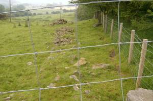 | |
