|
| *****SWAAG_ID***** | 119 | | Date Entered | 06/02/2011 | | Updated on | 06/02/2011 | | Recorded by | Tim Laurie | | Category | Settlement | | Record Type | Archaeology | | SWAAG Site Name | | | Site Type | | | Site Name | | | Site Description | | | Site Access | Public Footpath | | Record Date | 06/02/2011 | | Location | | | Civil Parish | Grinton | | Brit. National Grid | SE 03756 98445 | | Altitude | 192m | | Geology | Drift over Hardraw Scar Limestone | | Record Name | Scooped curvilinear enclosed settlement and field system, west of Swale Hall. | | Record Description | Curvilinear (Sub-circular) stone walled enclosed homestead settlement comprising deeply scooped, levelled platform approximately 30m diameter internally with rear scarp and front apron, originally stone revetted-now largely quarried of stone, recessed into the north facing hillslope. Four visible stone founded round houses within. Located at the corner of a modern stone walled pasture and overlain by a farm access track. This homestead is within a low stone banked and deeply lynchetted field boundary system which is probably contemporary. Site B on Harkerside Inter-dike zone Interim Sketch Plan. Swaledale Ancient Land Boundaries Interim Report 199*, Figs.1 and 2. | | Dimensions | 30m diameter overall. | | Geographical area | | | Species | | | Scientific Name | | | Common / Notable Species | | | Tree and / or Stem Girth | | | Tree: Position / Form / Status | | | Tree Site ID | 0 | | Associated Site SWAAG ID | 0 | | Additional Notes | Stone built, curvilinear scooped platform settlements preceded by timber built Phases have been shown to have been occupied from the Prehistoric Iron Age through the period of Roman Occupation, throughout the Uplands of Northern Britain.(see Burgess, Jobey, Coggins and Fairless, RCHME Westmoreland, Laurie).
This site is very similar to Swale Hall Settlement Site A which is located 250m east, below the sheepfold adjacent to Swale Hall and is also comparable to the scooped settlement in pasture east of Harkerside Place, (Gri 44. 3090).
.
References:
Burgess, C.B. 1970, Trans D&N2, 1-26.
Coggins, D and Fairless K.J. 1980. Trans. D & N 5,31-8
Jobey, G. Arch. Aeliana 4th Series 38,1960,1-38; 39,1961, 87-102; 40,1962,47-58; 41,1963, 19-35and 211-215; 42,1964,41-64.
Laurie, T.C. 1986.An enclosed settlement near East Mellwaters Farm, Bowes, Co Durham. Durham Arch. J. Vol. 1, 35-39.
For discussion on the timber/stone succession in the north, see Jobey,G Arch. Aeliana 5,1, 1973,55-79; Burgess, C. in Burgess,C and Miket (eds), Between and Beyond the Walls, 1984,164-73
| | Image 1 ID | 261 Click image to enlarge | | Image 1 Description | Settlement west of Swale Hall. | 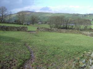 | | Image 2 ID | 262 Click image to enlarge | | Image 2 Description | Settlement complex west of Swale Hall. Linear earthwork slights settlements and field system of Romano British character. | 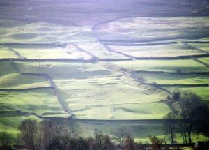 | |

