Close

This site uses cookies. No personal data is stored. You can read how we use them in our cookies policy. Continuing on this site accepts their use. Thankyou.

Viewing swaag.org website implies consent to set cookies on your computer. Full details Swaledale and Arkengarthdale Archaeology Group
Registered Charitable Incorporated Organisation Number 1155775
SWAAG Honorary President:
Tim Laurie F,S,A,

Another Search

Scroll Down the Record
 *****SWAAG_ID***** 367
 Date Entered 28/11/2011
 Updated on 28/11/2011
 Recorded by Ric Carter
 Category Rock Art
 Record Type Archaeology
 SWAAG Site Name 
 Site Type 
 Site Name 
 Site Description 
 Site Access Public Access Land
 Record Date 28/11/2011
 Location Munn End, Skelton Moor
 Civil Parish Marske
 Brit. National Grid NZ 07967 01892
 Altitude 356m
 Geology 
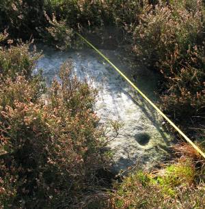
 Record Name cup-and- ring marked rock
 Record Description A single (visible) cup-and-ring marking, with groove, in the vicinity of others ( and numerous small, robbed-out cairns)on Skelton Moor recorded under this section of the database.
 Dimensions visible face of rock approx. 900mm x 600mm
 Geographical area 
 Species 
 Scientific Name 
 Common / Notable Species 
 Tree and / or Stem Girth 
 Tree: Position / Form / Status 
 Tree Site ID 0
 Associated Site SWAAG ID 0
 Additional Notes Recorded and photographed by R.Carter 27/11/2011
 Image 1 ID 1476         Click image to enlarge
 Image 1 Description  single cup-and-ring (and grooved) marked rock
PREV 20PREV 561 562 563 564 565 566 567 568 569 570 571 572 573 574 575 576 577 578 579 580 NEXTNEXT 20
Another Search