|
*****SWAAG_ID***** | 353 |
Date Entered | 25/11/2011 |
Updated on | 12/12/2011 |
Recorded by | Tim Laurie |
Category | Mining Related |
Record Type | Mining |
SWAAG Site Name | |
Site Type | |
Site Name | |
Site Description | |
Site Access | Public Access Land |
Record Date | 20/04/2010 |
Location | Fell End |
Civil Parish | Arkengarthdale |
Brit. National Grid | Hidden |
Altitude | 386m |
Geology | Kame terrace below the Main Limestone |
Record Name | Bale site with lead prill below Fell End. |
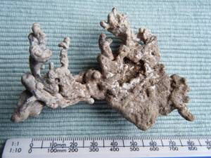
Record Description | Lead bale visible as erosion patch with slag and lead prill. See photo.
One of several lead bales on the westerly facing scarp slopes of below Fremington Edge and Fell End.
|
Dimensions | |
Geographical area | |
Species | |
Scientific Name | |
Common / Notable Species | |
Tree and / or Stem Girth | |
Tree: Position / Form / Status | |
Tree Site ID | 0 |
Associated Site SWAAG ID | 0 |
Additional Notes | |
Image 1 ID | 1422 Click image to enlarge |
Image 1 Description | Lead prill from bale site, Fell End. |  |