Close

This site uses cookies. No personal data is stored. You can read how we use them in our cookies policy. Continuing on this site accepts their use. Thankyou.

Viewing swaag.org website implies consent to set cookies on your computer. Full details Swaledale and Arkengarthdale Archaeology Group
Registered Charitable Incorporated Organisation Number 1155775
SWAAG Honorary President:
Tim Laurie F,S,A,

Another Search

Scroll Down the Record
 *****SWAAG_ID***** 927
 Date Entered 04/04/2016
 Updated on 28/07/2016
 Recorded by Ric Carter
 Category Mining Related
 Record Type Mining
 SWAAG Site Name 
 Site Type 
 Site Name 
 Site Description 
 Site Access Public Access Land
 Record Date 03/04/2016
 Location Below Fremington Edge
 Civil Parish Reeth
 Brit. National Grid Hidden
 Altitude 
 Geology 
 Record Name Quarryman's Shelter
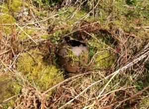
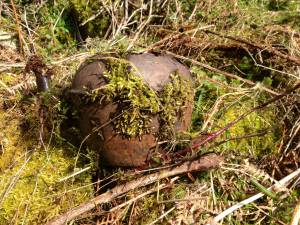
 Record Description Just off the public road up to the White House, below Fremington Edge, is a small, old, disused quarry usually overgrown with vegetation but at this time of year a rudimentary hearth could be found within the likely ruins of a quarryman's shelter and with this kettle still in situ - for one last brew!
 Dimensions 
 Geographical area 
 Species 
 Scientific Name 
 Common / Notable Species 
 Tree and / or Stem Girth 
 Tree: Position / Form / Status 
 Tree Site ID 0
 Associated Site SWAAG ID 0
 Additional Notes 
 Image 1 ID 6752         Click image to enlarge
 Image 1 Description Hearth
 Image 2 ID 6753         Click image to enlarge
 Image 2 Description Time for a last brew!
PREV 20PREV 61 62 63 64 65 66 67 68 69 70 71 72 73 74 75 76 77 78 79 80 NEXTNEXT 20
Another Search