| Viewing swaag.org website implies consent to set cookies on your computer. Full details | Swaledale and
Arkengarthdale Archaeology Group Registered Charitable Incorporated Organisation Number 1155775 |
SWAAG Honorary President:
Tim Laurie FSA |
The Swaledale and Arkengarthdale Archaeology
Group
Archaeological Report No. 2
The Daggerstones Survey
An Archaeological Survey of Daggerstones Farm above Healaugh
Peter Denison-Edson, Stephen Eastmead and Tim Laurie
September 2011
Support SWAAG and order a printed version

Contents
| Summary |
 |
|
| 1 | Introduction | |
| 2 | Location and Geology | |
| 3 | Study Definition | |
| 4 | The Survey Methodology | |
| 5 | Settlement Features | |
| 6 | Field Systems | |
| 7 | Other Features | |
| 8 | Discussion and Interim Conclusions | |
| 9 | Daggerstones Images | |
| 10 | Survey Maps | |
| 11 | Historical Maps | |
| 12 | Acknowledgments | |
| 13 | Bibliography | |
| 14 | Index | |
| Copyright | ||
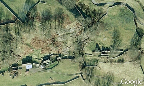
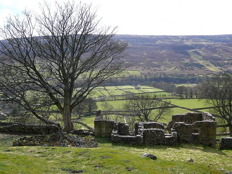
| Photograph 1: Daggerstones and Bank House ruins at the bottom of Goose Dubb. |
Summary
This report describes a complex multi-period landscape in the
pastures around the modern house at Daggerstones, and the ruins
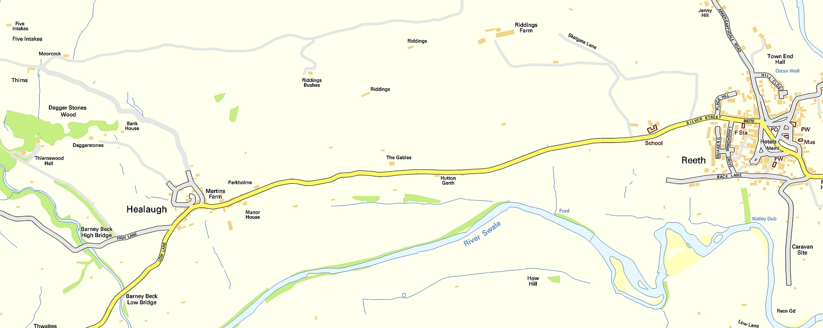
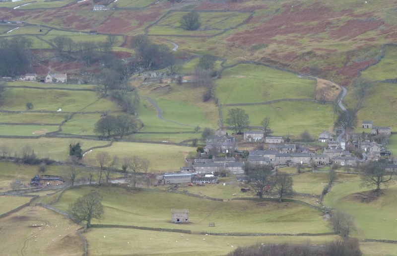
of Bank House (NGR SE015993) above the village of Healaugh on
the north side of Swaledale. The landscape ranges in elevation
from 210m OD to 305m OD and (visually) from Bronze Age mounds
through house platforms and lynchetted coaxial field boundaries
(broadly trending NNW-SSE) of Prehistoric/Romano-British
character, rectangular building platforms, and extant 17th
century ruins, to the sloped array of solar panels behind the
modern house at Daggerstones.
The settlement features of Prehistoric/Romano-British character, are denser close to a major high-level trackway which broadly follows the contour and traverses the site from Thirnswood to Shaw Gill and beyond to the east. This trackway can be traced along the north slope of the valley from Gunnerside to Reeth. Features of later character mainly lie downslope close to the modern village of Healaugh, but Bank House and rectangular building stances outside the survey area to the east lend weight to the suggestion that a linear settlement at this elevation may have preceded the modern concentration of population at the lower level around Healaugh. The Daggerstones settlement complex reinforces the conclusion that the density and distribution of Late Prehistoric/Native Roman Iron Age farmsteads located within the present day drystone-walled pastures was similar to that achieved when the population of farmer-miners in Swaledale was at its peak during the 19th Century. The field system associated with the Late Prehistoric/Romano-British farmsteads was respected by later farming, and it is clear that the fields were cultivated intermittently throughout subsequent periods to the present day.
1 Introduction1.1 Background
Aerial survey by Paul Chadwick of the North Yorkshire County
Council (NYCC) and by Robert White of NYCC and the Yorkshire
Dales National Park, and landscape surveys commenced during the
1970s by T.C. (Tim) Laurie, provided the background to the
Swaledale Land Boundaries Project 1984-1993 (SWALB).
Over a ten year period SWALB, directed by Andrew Fleming, then
of the Department of Archaeology and Prehistory at the
University of Sheffield, and Tim Laurie, identified and recorded
rich prehistoric/early historic landscapes in Swaledale,
characterized by extensive co-axial field systems on open
moorland, associated with unenclosed
cairnfield type settlements of Bronze Age date. SWALB also
recognized a Later Prehistoric Iron Age and Romano-British
landscape of farms and settlements within the present day
pastures on the lower dale slopes, generally below 300m OD. In
1990, the Yorkshire Vernacular Buildings Study Group surveyed
the ruins of Bank House next to the modern buildings at
Daggerstones (YVBSG Report No. 1306).
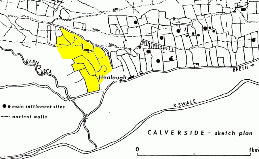
Following their work at Hagg Farm (SWAAG Archaeological Report No. 1), the Swaledale and Arkengarthdale Archaeology Group (SWAAG), have surveyed the archaeological evidence for human settlement and other activities within and adjacent to the walled pastures of Daggerstones Farm, which is located on the south facing hillside immediately above the present village of Healaugh (Figure 1). The overall site is referred to in this report as “Daggerstones”. 1.2 Prehistoric
SWAAG have recorded the surviving palimpsest of features which
attest to Prehistoric, Romano-British and later human settlement
and other activities at Daggerstones, previously unsurveyed.
Archaeological features within the pastures above Barney Beck in
the vicinity of Thirns, and Nova Scotia farms and in the
pastures above Healaugh immediately east of the moor road,
remain to be surveyed.
In assessing the landscape history and archaeological significance of Daggerstones, it is necessary to bear in mind that the surviving archaeological landscape at Daggerstones forms an integral part of an extensive complex of multi-period settlements on Calverside which have been identified, surveyed and discussed during the Swaledale Ancient Land Boundaries Project and subsequently (Fleming and Laurie 1985-1994; Fleming 1998, Figure 1.5; Laurie et al 2011, Figures 6.1, 6.12-13; and Figure 1 and Figure 2 in this Report). In brief, evidence for intensive settlement of Prehistoric and Romano-British character survives within the present day walled pastures of the lower dale sides and on the higher moorland across the full length of Cringley Hill, Calver Hill and Riddings Rigg - from Fore Gill Gate to the Arkengarthdale Road. This evidence consists of grouped house platforms within associated strongly lynchetted fields and cultivation terraces. These settlements are especially concentrated and well preserved within and above the pastures above Barney Beck, to the west of Daggerstones, and above Healaugh east of Daggerstones (Figure 2). Evidence for early settlement has been erased by the heavily cultivated and terraced pastures immediately west of Reeth (Reeth Medieval West Field, Fleming (op. cit.) figure 1.3) and also in the pastures immediately above Healaugh to the east of the moor road. In contrast, the field boundaries of Late Prehistoric age which are so prominent on the steep dale slopes above and to the east of Healaugh (and at Daggerstones) appear to have been respected during later periods. High above the present day walled pastures of Calverside- on the higher open heather slopes of Reeth Low Moor - an early fossilised landscape survives in the form of stone banked field systems defined by very substantial stone banks which attain an elevation of 400m on Cringley Hill and on Calver Hill. Within these high field systems are extensive remains of earlier Bronze Age settlements in the form of round burial cairns, ring cairns, scraper dominated lithic scatters, clearance cairnfields, irregular stone banked fields, burnt mounds and isolated circular enclosures. Traces of this early pioneering pastoral settlement activity also exist at lower elevations within the walled pastures of the lower dale Sides, as at Daggerstones (see below). 1.3 Historic
Fleming (op. cit. p40-44) first recognised and described the
archaeological and place-name evidence for the existence of an
‘Old Healaugh or Daggerston’ above the present village of
Healaugh, with the modern buildings at Daggerstones and the
adjacent ruins of Bank House as surviving dwelling sites within
what was once ‘Old Healaugh’.
Archaeological evidence for Old Healaugh survives in the form of rectangular buildings plots of Medieval and Post-medieval age located on and above the line of the contouring trackway from Thirnswood passing in front of Daggerstones and Bank House to cross the gated road through Shaw Gill and continuing towards Riddings and thence to Reeth. Trackways from the higher moorland address this contouring track rather than the modern road from Healaugh to the moor. Fleming concluded that ‘Old Healaugh’ predated the present village of Healaugh (“high clearing”), then a clearing in wood pasture of the Township of Reeth. Attractive as this suggestion may be, an alternative conclusion could be that Healaugh is now a shrunken village and was once more extensive, including ‘Old Healaugh’ consisting of the substantial farms at Daggerstones and Bank House together with a series of abandoned farmer-miner cottages on steep marginal land above the main village. This interpretation is supported by the fact that the strongly lynchetted fields at Daggerstones and west of Shaw Gill can be considered as the cultivated fields of medieval Healaugh located as it exists today. A further aim of this survey has therefore been to clarify the evidence for ‘Old Healaugh’ which exists within the survey area. 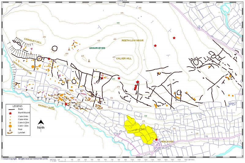 Figure 1. Reeth Low Moor and Barney Beck Pastures. As Laurie 2011 Figure 6.12 but with Daggerstones Study Site outlined in yellow. See also Fleming (op. cit.) Figure 9.7 for settlements within the walled pastures East of Healaugh.
The survey area rises from approximately 210m OD in the south-east in Ellas Field (OS Field 6111) on the outskirts of Healaugh to approximately 305 OD where High Pasture Field (OS Field 3242) abuts the Healaugh-Thirns-Nova Scotia road. Land-use is predominantly pasture, generally relatively unimproved on the well-drained upper slopes (which are dissected by large glacial run-off channels), and more heavily improved closer to Healaugh with wet, sometimes marshy ground around spring lines and at the margins by Healaugh. Survival of ancient field boundaries and settlement sites within these pastures is generally very good, features being prominent as visible earthworks in open ground and (in the case of field boundaries) underlying later dry-stone walls.
The modern house at Daggerstones is built on the Simonstone Limestone. Behind it is a steep slope of hard sandstone, heavily fractured and shattered into large blocks which lie in situ, above which are further bands of the series, leading eventually to the higher Middle Limestone on Calverside. Springs emerge above impervious shale bands below limestone strata throughout the site, most strikingly in Low Shorgill field where a series of spring mounds lie between two largely dry spring watercourses. See Figure: 9 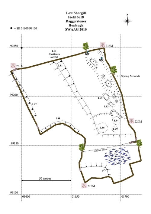 The soil is generally typical brown earth, a well-drained loamy soil overlying slowly permeable subsoils with slight seasonal waterlogging. The steep nature of the upper two-thirds of the site means that soil creep is a significant factor in evaluating surface features.
The maps produced were generated using a combination of free and low cost (£20) software using the following stages: GPS waypoints were downloaded into GPS TrackMaker (freeware) and lines were drawn connecting appropriate waypoints to describe both field boundaries and archaeological features. 1) When complete, an image of the final GPS TrackMaker screen was saved as a .jpg image file. 2) The TrackMaker image was then imported into the graphics program DrawPlus8, as Layer 1. Additional layers were generated using functions within DrawPlus8, to produce archaeological maps by tracing over the baseline GPS TrackMaker Layer 1 using suitable lines and symbols. Typically four additional layers were generated: a. British National Grid b. Field Boundaries c. Archaeology d. Text Labels On more complex maps, archaeology was divided into different layers e.g. Settlements, Mounds and Cairns, Trackways, Lynchets etc. A full description of the methodology is available at https://swaag.org/publications.htm Note: All SWAAG maps were drawn by S.P. Eastmead using the technique documented here The complex of sites in and adjacent to the Daggerstones fields do not lend themselves easily to interpretation. On the higher ground in the northern part of the site the features appear linked to the possible Bronze Age/early Iron Age systems of Calverside, with a possible extension to the known distribution of burnt mounds. Within the lower pastures a multi-period archaeological landscape survives, with a palimpsest of features which may represent Iron Age/Romano-British settlements, together with later sites of Medieval/Early modern appearance and extant 17th century and more recent remains. |
|||||||||||||||||||||||||||||||||||||||||||||||||||||||||||||||||||||||||||||||||||||||||||||||||||||||||||||||||||||||||||||||||||||||||||||||||||||||||||||||||||||||||||||||||||||||||||||||||||||||||||||||||||||||||||||||||||||||||||||||||||||||||||||||||||||||||||||||||||||||||||||||||||||||||||
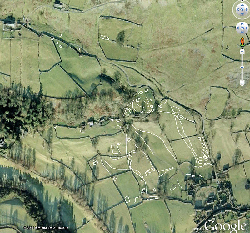
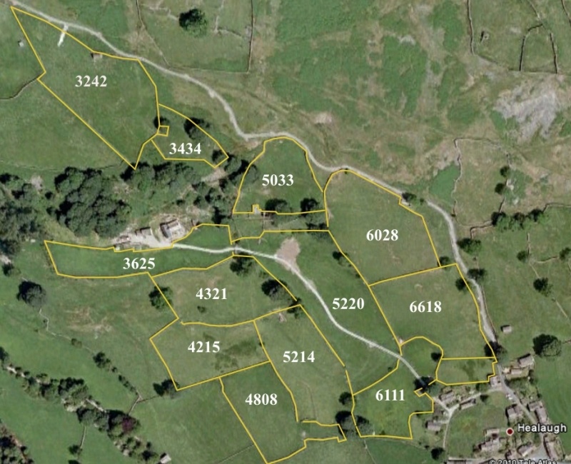 Photograph 4: Daggerstones OS Field Numbers ©Google Earth 2010 |
5.3.1 High Pasture (OS Field 3242)
Above High Pasture and the modern road are two possible house platforms. HP5 is a rectangular building base of Medieval/Most-medieval character 23m x 5m, flanked to the south by a coal and charcoal scatter but without visible evidence of midden remains. HP10 is a smaller platform with evidence of a stone founded structure.
The Daggerstones Antler, a most interesting find. During the reconstruction of the fine sheep stell HP6 located at the southern boundary of High Pasture, a well preserved calcined single antler of a very large red deer was discovered within the foundation of the stell. Since the antler was placed within the foundations of the dry stone wall of the stell, and not in the subsoil below the stell, it seems that this object was placed as a good luck token by the builders of the stell. Accordingly the original provenance of this antler is uncertain. In appearance, it resembles the large antlers recovered from many Neolithic earthworks and from Late Mesolithic cemeteries.
It would be pure speculation that this antler was found during the excavation of the foundation trench for the stell and redeposited. If it was so found, the implications for the existence of burials contemporary with the antler at this place would need to be considered. See Section 7.4 for further discussion of this find.
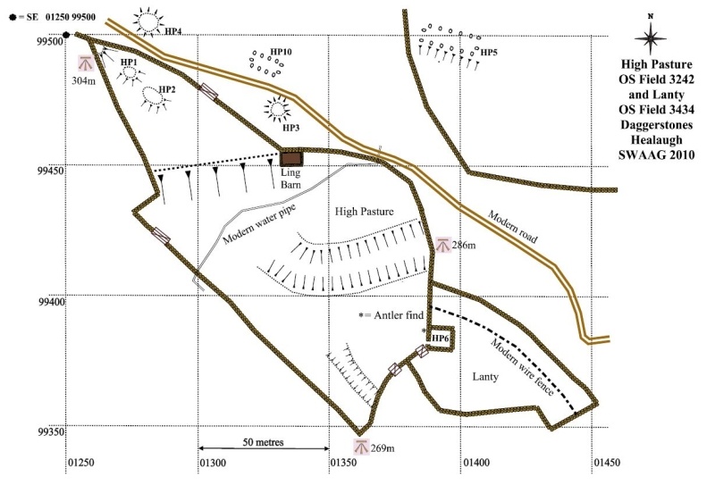 Figure 4: High Pasture (OS Field 3242) |
5.3.2 Goose Dubb (OS Field 5033)
A further trackway runs N from the junction of the main track and track GD16 (see below) to split as GD19 & GD20 on either side of a steep dry valley and run up to the modern road from Healaugh to Thirns and Nova Scotia.
Track HS2 (see High Shorgill) enters the field from the E and appears as GD17 to run NW below a steep sided detached eminence or hillock above circular platforms GD7 and GD8 to a large flattened area identified on the plan as a yard. A side track GD18 leaves this extension of GD17 to run up to artificially levelled summit of the eminence which is the location for a circular embanked feature, GD1, provisionally identified as a round house.
Track GD16 leaves to the NW from the main track, passes between slight platforms GD14 and GD15 (both possible levelled building stances) then along the crest of the pronounced break of slope and below platforms GD6-8 and continues through what has the appearance of a pre-enclosure wall as a hollow-way in the direction of the fragmented scarp and woodland above Daggerstones House.
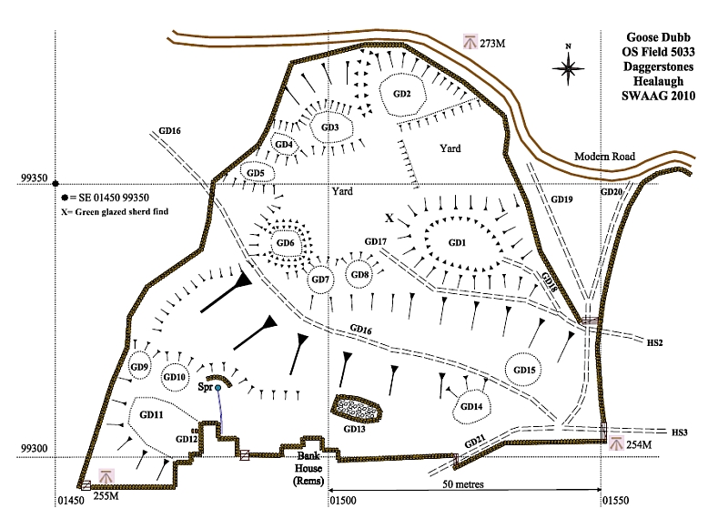 Figure 5: Goose Dubb (OS Field 5033) 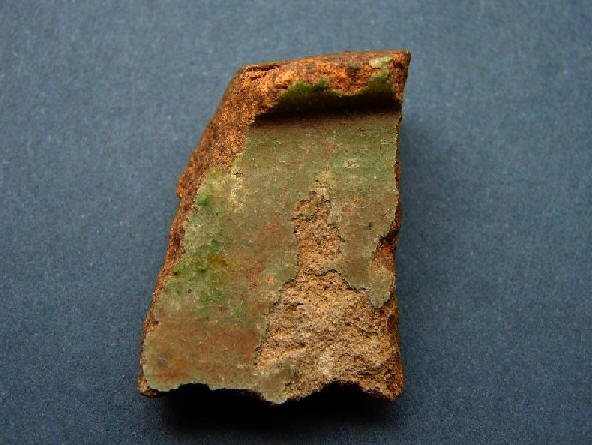 Photograph 5: Medieval pottery sherd (approx. 30x40mm) found at position X north west of GD1 |
Settlement features in Goose Dubb must be assessed with caution because the site appears to have been intensively used for many centuries in connection with the farm at Bank House on its southern edge. The current remains of Bank House have been dated to the 17th century on possible earlier foundations, and medieval records contain a reference in 1301 to “Ralph of the Bank”. In the north-west of the field lie four circular/ovoid platforms which appear to be scooped into the steep hillside. Below them lie two flat/flattened areas described on the plan as yards, either or both of which could also be interpreted as stances for rectangular buildings. The easternmost has slight scarps on its north and west sides. To the south of the yards is the large natural mound at GD1, with steep outer slopes and a possible embanked summit with a slightly indented centre, to which leads a track through a possible E entrance. Further west, above GD16, platforms GD7 and GD8 appear scooped into the hillside on their northern edge and utilize the steep natural slope to their south. Below track GD16 and the very pronounced scarp on which it stands are two circular platforms GD9/10 slightly scooped into the hillside (GD10 could possibly be the remains of the goose pond from which the field derives its name), a strong spring with significant features around it suggestive of medieval/modern water-control, a modern walled stone dump GDS13, and a large ovoid platform GD11 with pronounced slopes falling away to the south. This could be interpreted as a yard relating to GD9/10 or to Bank House. Two stones (GD12) set in the earth with a narrow gap between are possible supports for a circular grindstone for knives or other types of blade.
5.3.3 Daggerstones Close (OS Field 3625)
Daggerstones Close field lies below the modern house and gardens at Daggerstones. It contains much-disturbed slight features, DC1-6, both circular and rectangular. These features may relate to or predate the current house and its predecessor.
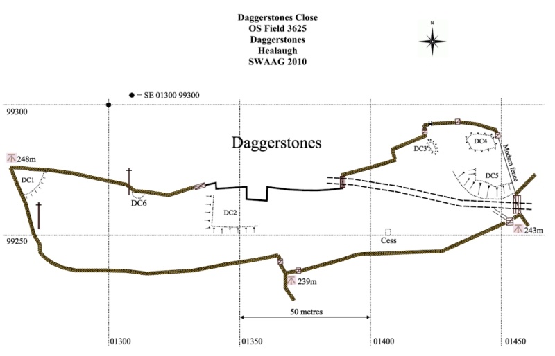 Figure 6: Daggerstones Close (OS Field 3625) |
5.3.4 Croft (OS Field 5520)
Croft field is bisected NNW to SSE by the trackway to the modern house at Daggerstones which lies atop a pronounced lynchet CR1. Long stretches of the west and east walls are built atop and respect slighter lynchets parallel to CR1, CR5 and CR6 for the west wall and a complex series of lynchets under and beside the east wall. The east wall lies on a lynchet representing one phase of land use, but is bounded on its eastern side by a lynchet apparently older than the lynchet on which it stands, and by a further slight lynchet on its western side. Three lynchets, CR2, CR4 and CR6 run at right angles to the lynchets mentioned above. The south wall of the field lies atop lynchet CR4. At the foot of the field between CR2 and CR4 is a burnt mound CR3 and slight evidence of a possible settlement site.
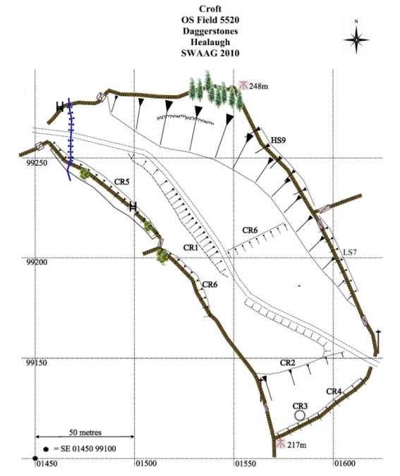 Figure 7: Croft (OS Field 5520) |
5.3.5 High Shorgill (OS Field 6028)
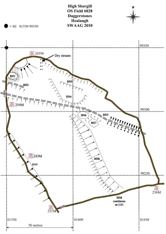 Figure 8: High Shorgill (OS Field 6028) |
High Shorgill is bisected NNW-SSE by the pronounced bank or lynchet HS8 with a slighter lynchet cut into its western face. The west wall lies above lynchet HS9 which runs parallel to HS8 and part of the north wall appears to lie above lynchet HS5.
A circular/ovoid platform HS1 and a natural knoll lie in the north-west corner of the field above a trackway HS2 leading to the complex settlement features in Goose Dubb (OS Field 5033). HS2 is not visible at its E end but could reasonably be expected to have joined the main track HS3.
A large trapezoidal platform HS4 lies north of the main track HS3, and two platforms HS6 and HS7, either ovoid or rectangular but slightly obscured by soil-creep, adjoin it to the south.
5.3.6 Low Shorgill (OS Field 6618)
Low Shorgill field contains two parallel NNW-SSE lynchets: LS7 on which is built the northern part of the west wall, and LS1 which bisects the field and turns to the east below the settlement platforms LS4-LS6, and above a strikingly marshy area at the bottom of the field. LS1 steepens to the north and runs through the field wall after which it is numbered HS8. LS1 is flanked on west by a slight lynchet at its base. The western wall curves to the east in its lower half, apparently respecting the curving lynchet LS8 which appears to be a continuation of LS7.
 Figure 9: Low Shorgill (OS Field 6618) |
A striking aspect of Low Shorgill is the string of mounds beside two spring courses in its eastern half, running from springs rising at or close to the north field wall. What appear to be at least five spring mounds lie between the two spring channels, with two turfed over stone mounds LS2 and LS3 located just below the confluence of the two spring courses. These two mounds have been proved to be composed of burnt stone and are interpreted as a burnt mound site.
5.3.7 Cowling Acre (OS Field 4321)
The east wall of Cowling Acre sits on the downslope of a pronounced lynchet, CR6 (numbered for the adjacent Croft field), with a relict wall to the west above a slight lynchet CA2. The eastern part of the south wall lies on the downslope of lynchet CA7. In the western part of the field, parallel to CR6 is a slighter lynchet CA8 which includes relict hawthorn CA6. CA5 is a levelled platform which may be the stance for a rectangular building. CA1 and CA9 are clearance cairns, and the ovoid features CA3 and CA4 either side of the spring are of unknown provenance.
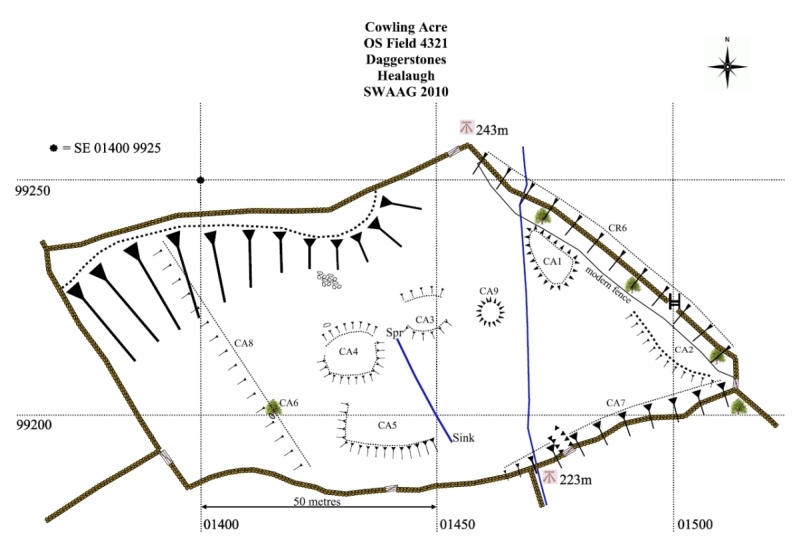 Figure 10: Cowling Acre (OS Field 4321) |
5.3.8 Hallgarth (North) (OS Field 4215)
Hallgarth (North) is bisected by an active spring in a steep-sided valley, leading to a marshy area. There is evidence of herringbone drainage channels above the marsh, of unknown date. Two conjoined sub-rectangular features, HN1 and HN2 with a further adjoining slight sub-rectangular feature, all of unknown date, lie in the higher north-west corner of the field. These conjoined features may prove to be the remains of an early homestead settlement. There is a large west-facing lynchet in the adjoining field to the West, not surveyed.
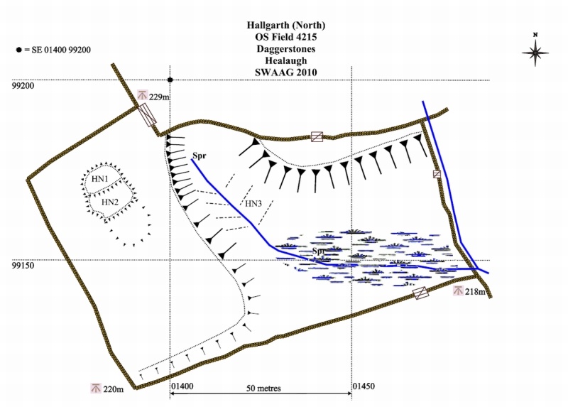 Figure 11: Hallgarth (North) (OS Field 4215) |
5.3.9 Hallgarth (South) (OS Field 4808)
Hallgarth South may prove to contain a most interesting area of surviving archaeological remains with visible stone structures which represent a range of rectangular buildings at the lower southern end of the field. Two possible circular platforms, HS1, are located at the north-east corner, one cut by a field wall. HS3 is the remains of a collapsed barn. HS4 and HS5 stand beside a thick field wall, 1.5m wide which they appear to pre-date.Written records refer to a hunting lodge of John of Gaunt named Hall Garth in the general area of Healaugh but without excavation it is impossible to say whether the extant remains and the field name preserve the physical location of the hunting lodge or merely the folk memory that such a place existed in the general area.
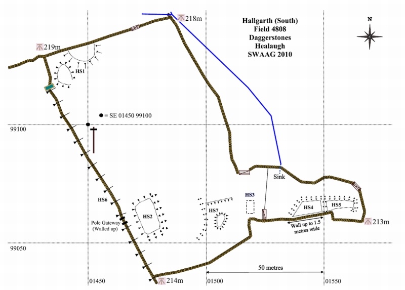 Figure 12: Hallgarth (South) (OS Field 4808) |
5.3.10 Low Close (OS Field 5214)
Low Close field contains an active spring stream running through a shallow valley along its western side. Its northern wall, bounding Cowling Acre sits on the downslope of lynchet CA7 (see Cowling Acre). The east wall traverses a long NNW-SSE lynchet which decreases in height to the south. The northern part of this wall lies on the downslope of lynchet CR6 (see Croft) and below the traverse the wall lies above the lynchet continuation numbered as LC7.LC1 and LC2 have the appearance of stances for two rectangular timber structures (a possible dwelling site) on a low platform which abuts lynchet LC7 on its western side. These features are associated and relate to the substantial lynchet field boundary which appears to have been stone face revetted at the eastern end of the platform which abuts the lynchet.
Excavation of these platforms and determination of the structural relationship with the lynchet offers an opportunity to obtain evidence for the chronology of the lynchetted field system. LC3/4/5/6 are unexplained features.
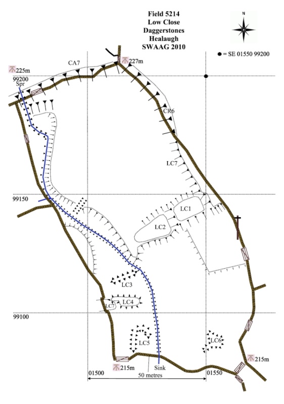 Figure 13: Low Close (OS Field 5214) |
5.3.11 Ellas (OS Field 6111)
Ellas field, which lies on the edge of the modern village of Healaugh, is cut by the modern access road from the house at Daggerstones and contains an active spring flanked by a possible spring mound. Its north-west wall, shared with Croft field (OS Field 5520) lies on the downslope of lynchet CR4 (see Croft) and the north-east wall shared with Low Shorgill (OS Field 6618) sits below the top of curving lynchet LS8 (see Low Shorgill). It contains two unexplained raised mound features: EL1 located at the upper edge of the marsh, a location characteristic of burnt mounds, and EL2. Burnt stone has not been recognised at EL1 which is wholly vegetated, but a second burnt mound site here has not yet been ruled out.
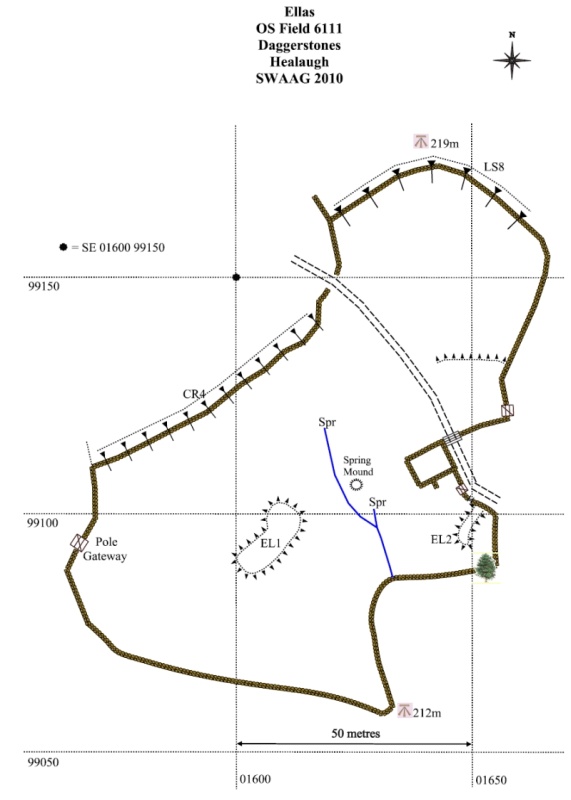 Figure 14: Ellas (OS Field 6111) |
6 Field Systems
Perhaps the most visible and constant features to be seen within the present day dry-stone walled pastures of Daggerstones Farm are the stongly lynchetted or embanked terrace-like boundaries which run downslope through the fields and also directly beneath the dry-stone walls of the present day. These lynchets are the product of cultivation against a boundary (i.e. hoe or oxen drawn plough cultivation) of the steep but fertile daleside above Healaugh during very many centuries, perhaps millennia. Many of the lynchet slopes show evidence of re-cutting, implying observance of earlier boundaries already established.The lynchet boundaries define a pattern of fields which extends across the whole of the daleside north of Healaugh. Individual fields may be visible as narrow strips running obliquely to the slope as with the prominent examples in the steep field immediately to the east of the modern Moor Road. Alternatively these fields can be seen as comparatively wide level areas, true fields, as for example the field formed between LS1, LS7 and LS8 in Low Shorgill Field (Figure 9).
The date of the origins of these lynchetted field boundaries is of considerable interest. One of us (T.C.L.) has observed that the small house platforms and the larger farmstead-size settlement platforms of Late Iron Age and Native Roman Age located within the present day walled pastures above Healaugh are also directly associated with the lynchet boundaries. Furthermore, that the cultivation processes which had formed the lynchets had not slighted the group of six platforms North of Healaugh, one of which was excavated during the SWALB Project and dated to the Late Iron Age through to the period of Roman occupation.(Fleming op. cit., Fleming and Laurie op. cit.)
Thus, the evidence suggests that the lynchet boundaries have their origins within the Late Iron Age and also that these fields were occupied, abandoned and reoccupied throughout all subsequent periods until finally enclosed within the stone-walled pastures of today.
In their final form these lynchetted fields would have provided the bread and butter, the basic livelihood of the farmer miners of Healaugh and Old Healaugh throughout the medieval and historic period right up to the enclosure Acts of the Late 18th C.
It may seem strange that the lynchets run downslope and are not generally on the contour, as for example the prominent lynchet terraces of Reeth West Field. Surely every shower of rain would wash the topsoil downslope. Be this as it may, the fields do run downslope and perhaps were easier to cultivate by hand or by oxen.
The small settlements located in Goose Dub Field (Figure 5) and within High and Low Shorgill (Figures 8 and 9) are either directly associated with the lynchet boundaries or are well situated to be associated with these early fields.
Finally, the extensive complex of platform settlements and cultivation terraces located within the walled pastures above Barney Beck and also extending to the high open moorland to the west of Thirns and above Nova Scotia are directly associated with the coaxial field systems of mid Iron Age Date on Calverside West (Laurie, T.C. et al, 2011, Figure 6.14 Locations R2-R4).
There are indications of the existence of a coaxial field system associated with the early settlements at Daggerstones on the open moorland directly above High Pasture and Goose Dub Fields. Further fieldwork will be necessary to confirm this.
7 Other Features
7.1 Trees and Hedges
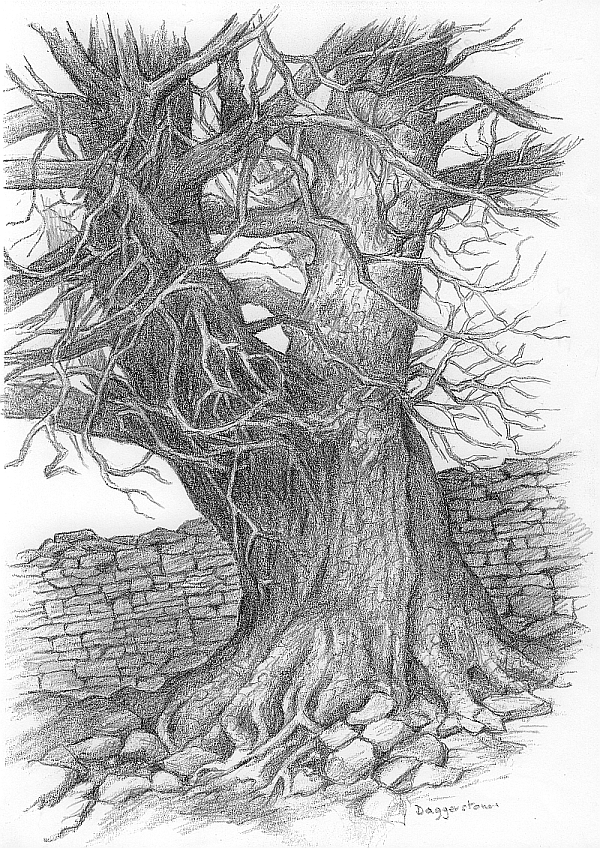
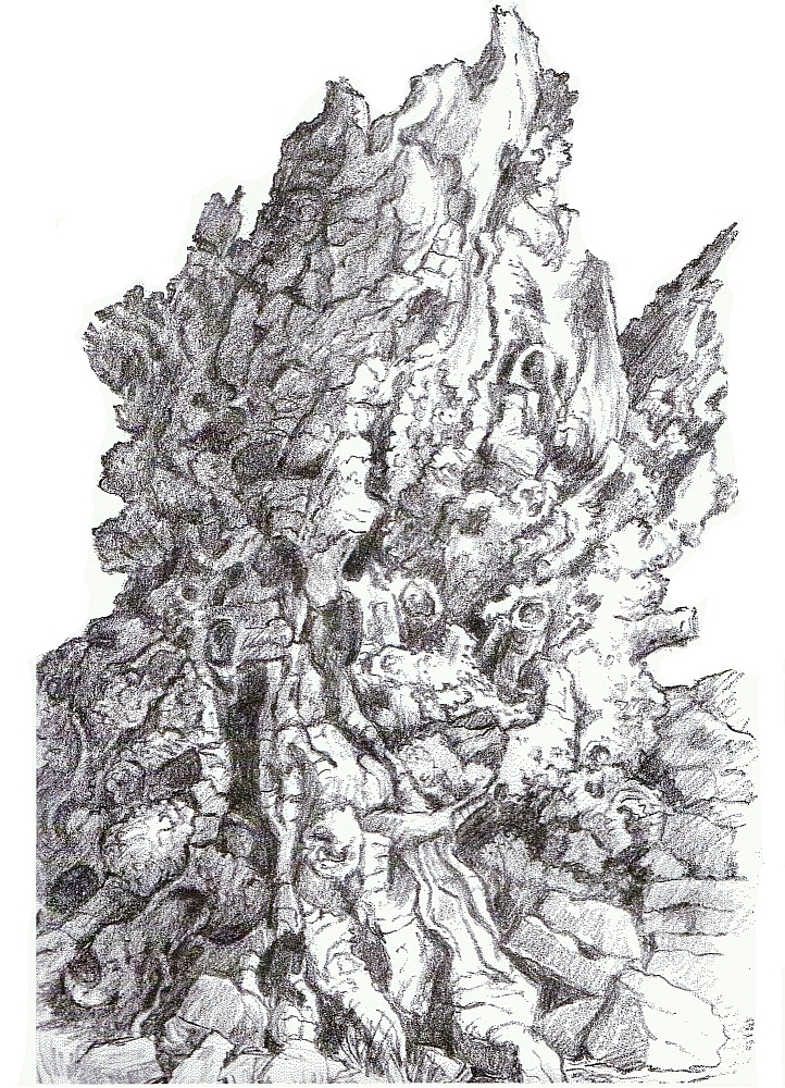
Figure 15: Sycamore and dry stone wall, Daggerstones. A sketch by Jocelyn Campbell.
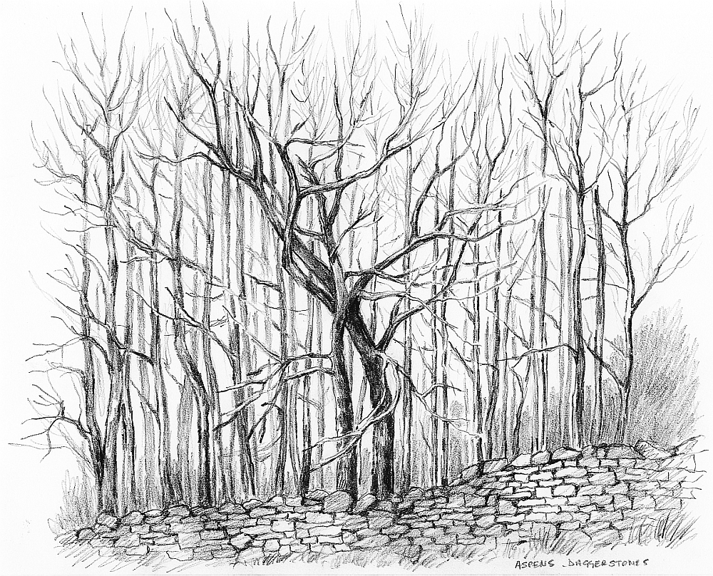
The aspen grove at the top of Croft field (5.3.4), (Photograph: 6 and Figure: 17) comprises the cloned ramets or ongrown root sucker shoots which are the offspring of an older mother tree. Whereas these aspens are not individually old, this cloned colony could represent continuous regeneration of the same tree and thus represent a vestige of ancient woodland.
 |
 |
| Figure
16: Remnant of ancient Wych Elm pollard, now dead
from Dutch Elm Disease. A sketch by Jocelyn Campbell. Click image to enlarge. |
Figure 17: Aspens. Mother tree
and her offspring. A sketch by Jocelyn Campbell. Click image to enlarge. |
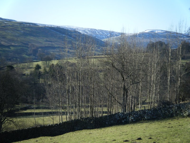 Photograph 6: Aspens: Looking from field 5.3.5 High Shorgill (OS Field 6028) south west to the top of field 5.3.4 Croft (OS Field 5520). Image Tim Laurie 2010. |
7.2 Mounds
Mounds found within the survey area have the appearance of field clearance mounds, a possible small ring cairn, burnt mounds, or natural spring mounds. No definite evidence exists for burial mounds (barrow mounds).7.3 Trackways / Pathways
As detailed above, the settlements described in Section 5 lie astride the major W-E high-level trackway along the North side of the Swale valley. Minor trackways, usually in the form of slight hollow ways, were present, associated with and within the settlements, and generally respecting the “main road”. Because of the multi-period nature of the site, it is not possible from landscape survey evidence alone to determine whether particular trackways relate to Prehistoric/Romano-British settlement or to later activity. This is especially true of the quite dense network of tracks in Goose Dubb field, where proximity to what may have been a substantial Medieval/Early-modern/Modern farm at Bank House makes analysis difficult without intrusive investigation.7.4 Other finds
A fossilized (calcined) antler was found in the footing of the walled enclosure, possibly a lambing pen, shown as HP6 on the High Pasture map (5.3.1 above). It seems unlikely that the antler is in its original position but it could have been re-buried where it was found when the wall was rebuilt at some unknown date. SWAAG will attempt to have the antler dated, on the clear understanding that while the antler appears to be far larger than modern specimens, calcination can occur very rapidly and may not indicate great antiquity.
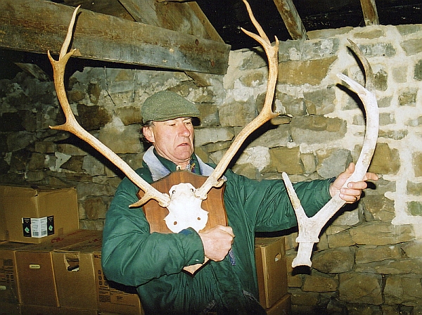
Photograph 7: Jeremy Morrogh-Ryan holding the calcined red deer antler with a much smaller
modern red deer trophy antler for comparison. Image Tim Laurie 2010.
8 Discussion and Interim Conclusions
Section 8 (Discussion and Interim Conclusions) of SWAAG Archaeological Report No. 1 (op. cit.) rehearsed the historiography of our knowledge and interpretation of Late-prehistoric/Romano-British settlement in the Yorkshire Dales, and the work of Laurie and others in revolutionizing the traditional picture of a poor, lightly populated and marginal area. It also speculated on the nature of Late-prehistoric and Romano-British society and the economy in Swaledale.
Our survey evidence suggests that Prehistoric and Romano-British settlement and activity on the Daggerstones site accords well with the picture presented by Laurie, Fleming and the SWALB (op. cit.), with unenclosed settlement situated within an organized framework of co-axial field systems (itself broadly aligned with more extensive and possibly earlier systems on the moorland above). In particular the site lies on and respects a major, though undated, route-way along the northern dale-side. A clearer picture can, however, only emerge through further work including targeted excavation.
The Post-Roman and Medieval/Modern dimensions of Daggerstones also requires further study. The site was clearly actively used. The evidence on the site and in adjacent areas suggests both agricultural and mining activity in the Medieval, Early-modern and Modern periods. The site is close to mining areas on the moorland above, and linked to the moor by trackways.
A major area for study is the relationship between the Daggerstones area as a site pre-dating (if Fleming is right) the later village of Healaugh, and the decline of Daggerstones and ascent of Healaugh, and whether the apparent rectangular structures in the lower fields at Daggerstones belong to “new” Healaugh as a shrunken village, or to Daggerstones as “Old Healaugh” or to an intermediate phase of development.
More detailed focus on trackways could help to indicate how settlements in general were inter-related, whether the main communications routes were linear along the valley sides and whether there were links to the valley bottom in this period.
Only intrusive excavation offers the prospect of more precise dating within the broad time-frame of Bronze Age/Iron Age/ Romano-British/Medieval/Modern dating, and thus of attempting to understand how the evidence identified in this survey relates to the broader issues of the rural economy of Swaledale through time.
9 Daggerstones Images
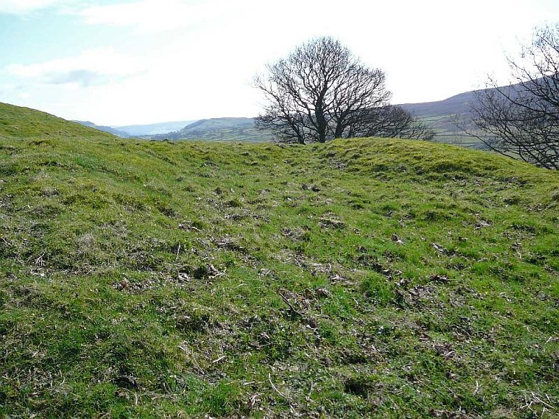
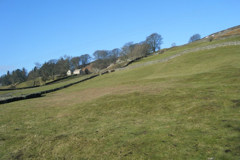 Photograph 8: View of 5.3.6 Low Shorgill (OS Field 6618) from near gate. LS4 in foreground. Image Tim Laurie 2010. |
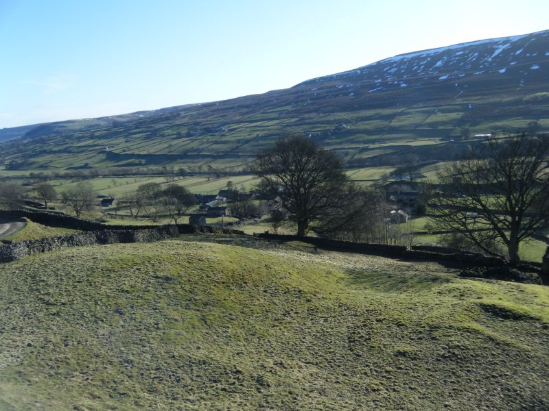 Photograph 9: 5.3.5 High Shorgill (OS Field 6028) Looking south east at platform HS1. Trackway HS2 on extreme right. Image Tim Laurie 2010. |
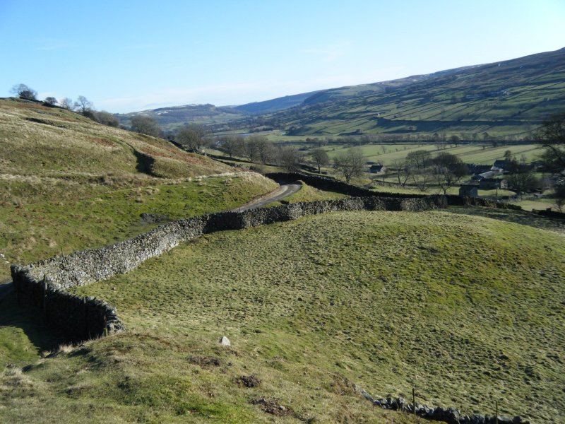 Photograph 10: 5.3.5 High Shorgill (OS Field 6028) Looking south east from knoll at HS4 and HS5. Image Tim Laurie 2010. |
 Photograph 11: 5.3.2 Goose Dubb (OS Field 5033) looking south east at GD1 with Trackway GD17 on right. Image Tim Laurie 2010. |
 Photograph 12: 5.3.2 Goose Dubb (OS Field 5033) Bank House with trackway GD16 in the foreground. Image S P Eastmead 2010. |
 Photograph 13: 5.3.2 Goose Dubb (OS Field 5033) Looking south east at GD6 with trackway GD17 around south of knoll at top left. Image S P Eastmead 2010. |
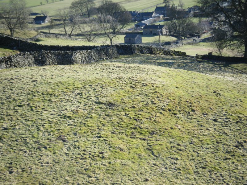
 Photograph 14: 5.3.10 Low Close (OS Field 5214) View from near LC3 towards LC2 and LC1 looking north east. Image S P Eastmead 2010. |
 Photograph 15: 5.3.10 Low Close (OS Field 5214) View from the South looking North. Left of spring LS3 (foreground), then LC4 and LC5. On right side of spring towards the top left side of LC2. Image S P Eastmead 2010. |
10 Survey Maps
All 11 of the survey maps can be download as high quality pdf files and .jpg images here
11 Historical Maps
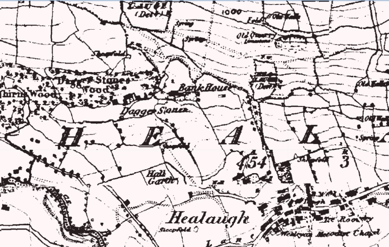 Figure 18: Map 1846-1863 |
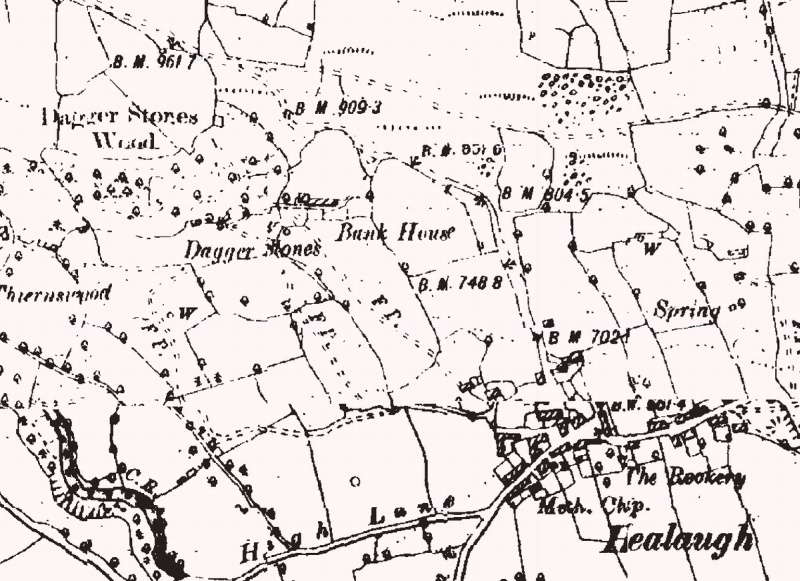 Figure 19: Map 1899-1899 |
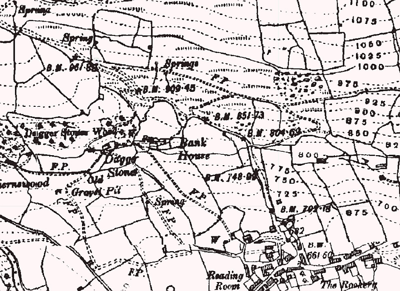 Figure 20: Map 1907-1924 |
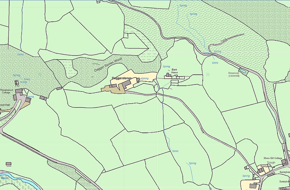 Figure 21: Map showing the rich supply of spring water. |
12 Acknowledgments
The OS Street View maps are supplied under the OS Open Data licence.
13 Bibliography
A fuller bibliography relevant to
Prehistoric and Romano-British topics can be found at Appendix
5 in SWAAG Archaeological Report No.1 [http://www.swaag.org/publicationsSWAAG02.htm]
Fleming, Andrew, 1998 (reprinted 2010,
Oxbow Books). Swaledale: Valley of the
Fleming, Andrew and Laurie, Tim,
1984-1993. Annual Interim Reports of the Swaledale Ancient Land
Boundaries (SWALB) Project [http://www.swaag.org/publications_TimLaurie_InterimReports.htm]
Laurie, T.C., 1984. An Enclosed
Settlement near East Mellwaters Farm, Bowes, Co
Laurie, T.C., 1985. Early Land Division and Settlement in Swaledale and on the eastern approaches to the Stainmore Pass over the North Pennines, in Upland Settlement in Britain: the Second Millennium B.C. and after, ed. Don Spratt and Colin Burgess, BAR British Series 143, pp. 135-162. [http://www.swaag.org/publicationsTL2.htm
Laurie, T.C., 2003. Researching the
prehistory of Wensleydale, Swaledale and Teesdale, in The
Archaeology of Yorkshire: an assessment at the beginning of the
21st century ed. T.G. Manby, Stephen Moorhouse and
Patrick Ottaway, Yorkshire Archaeological Society Occasional
Paper No.3 pp 223-254. [http://www.swaag.org/publicationsTL4.htm]
Laurie, T.C., 2004. Springs, Woods and Transhumance: reconstructing a Pennine Landscape during Later Prehistory in Landscapes Volume 5 No. 1, Windgather Press, Spring 2004 pp 73-102. [http://www.swaag.org/publicationsTL5.htm]
Laurie, T.C. with Mahaffy N.W. and White, R.F. 2011. Coaxial field systems in Swaledale: a reassessment following recent fieldwork. In R.D. Martlew, Ed. Prehistory in the Yorkshire Dales recent research and future prospects. PLACE/Yorkshire Dales Landscape Research Trust. [http://www.swaag.org/publicationsTL15CFS.htm]
Tim Laurie, Stephen Eastmead and Peter Denison-Edson 2010. Swaledale and Arkengarthdale Archaeology Group (SWAAG). Archaeological Report No.1, An Iron Age/Romano-British landscape at Hagg Farm [http://www.swaag.org/publicationsSWAAG02.htm]
YVBSG, 1990. Yorkshire Vernacular Buildings Study Group Report no. 1306: Bank House, Healaugh, Reeth, North Yorkshire.
14 Index14.1 Sections |
||||||||||||||||||||||||||||||||||||||||||||||||||||||||||||||||||||||||||||||||||||||||||||||||||||||||||||||||||||||||||||||||||||||||||
|
||||||||||||||||||||||||||||||||||||||||||||||||||||||||||||||||||||||||||||||||||||||||||||||||||||||||||||||||||||||||||||||||||||||||||
14.2 Figures |
||||||||||||||||||||||||||||||||||||||||||||||||||||||||||||||||||||||||||||||||||||||||||||||||||||||||||||||||||||||||||||||||||||||||||
|
||||||||||||||||||||||||||||||||||||||||||||||||||||||||||||||||||||||||||||||||||||||||||||||||||||||||||||||||||||||||||||||||||||||||||
14.3 Photographs |
||||||||||||||||||||||||||||||||||||||||||||||||||||||||||||||||||||||||||||||||||||||||||||||||||||||||||||||||||||||||||||||||||||||||||
|
||||||||||||||||||||||||||||||||||||||||||||||||||||||||||||||||||||||||||||||||||||||||||||||||||||||||||||||||||||||||||||||||||||||||||
Copyright

Archaeological Report No. 2, The Daggerstones Survey by
Swaledale and Arkengarthdale Archaeology Group is licensed under a
Creative Commons Attribution-NonCommercial-NoDerivs 3.0 Unported License.
Based on a work at www.swaag.org.
Webpage: S P Eastmead