|
| *****SWAAG_ID***** | 983 |
| Date Entered | 17/03/2017 |
| Updated on | 17/03/2017 |
| Recorded by | Tim Laurie |
| Category | Settlement |
| Record Type | Archaeology |
| SWAAG Site | Low Whita |
| Site Access | Private |
| Record Date | 17/03/2017 |
| Location | Low Whita |
| Civil Parish | Grinton |
| Brit. National Grid | SE 005 982 |
| Altitude | 215m |
| Geology | Drift |
| Record Name | Curvilinear stone walled enclosed settlement and associated field system in pasture south of Scabba Wath Bridge. |
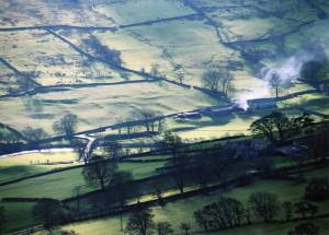
| Record Description | This large ovoid enclosed platform settlement is of Late Iron Age character but was almost certainly re-occupied during subsequent periods. The site is north facing but, as they say the grass grows best on the money side of Swaledale. Note the very substantial stone banks (originally long lived hedgerow banks) which define the associated field system. The field system boundaries extend upslope through the relict woodland of Horse pasture Wood. All in all, this is one of the largest and most attractive of the very many settlement sites in Swaledale.
For further details of this settlement, see also SWAAG Database Record No 444. |
| Dimensions | See photograph |
| Additional Notes | This tele photograph was taken several years ago under good light conditions from high on the northern slopes of Swaledale.
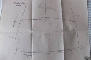
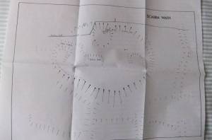
The survey plans show two circular and one rectangular building within the enclosure. It is probable that other rectangular buildings are located in the vicinity of the enclosure.
The very substantial stone banked field boundaries indicate that field system was clearly long lived. |
| Image 1 ID | 7237 Click image to enlarge |
| Image 1 Description | Settlement at Scabba Wath. Tele photo view from the North. |  |
| Image 2 ID | 7236 Click image to enlarge |
| Image 2 Description | Settlement and field system, Scabba Wath. Plane Table Survey Plan. 1:500 scale |  |
| Image 3 ID | 7235 Click image to enlarge |
| Image 3 Description | Settlement at Scabba Wath. Plane Table Survey Plan. 1:1000 scale |  |


