|
| *****SWAAG_ID***** | 795 |
| Date Entered | 31/03/2014 |
| Updated on | 31/03/2014 |
| Recorded by | Tim Laurie |
| Category | Settlement |
| Record Type | Archaeology |
| Site Access | Public Access Land |
| Record Date | 01/01/2005 |
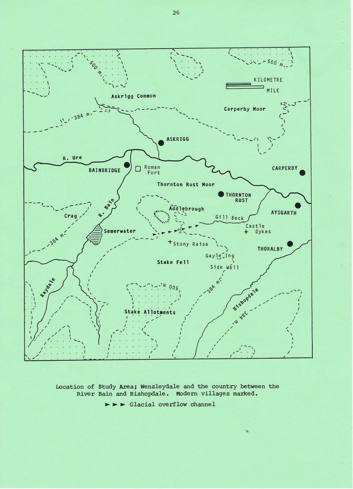
| Location | Semerwater, Addlebrough, Greenber Edge and Stake Fell |
| Civil Parish | Bainbridge |
| Brit. National Grid | SD 955 870 |
| Altitude | 420m |
| Geology | Lower Carboniferous strata of the Yoredale Series capped by Namurian strata (Millstone Grit) on the highest ground,(Kendall and Wroot 1924) |
| Record Name | An Archaeological Survey of Semerwater, Addlebrough and the Stake Road (Stake Fell) by Tim Laurie and Robin Minnitt prepared for the 1993 Summer Meeting of the Prehistory Society |
| Record Description | This summary of archaeological sites which were known at 1993 across a large area of the Pennine Uplands which overlook Semerwater and located elsewhere in Wensleydale, was undertaken to provide a background briefing document for the field walk to this area by members of the Prehistory Society within their programmed Summer Visit to Ripon and elsewhere in Western Yorkshire. Whereas this Survey was put together by Robin Minnitt and Tim Laurie who were guides to the Members on the field excursion, we were both grateful for and acknowledge the addition of information and final editing of Terry Manby.
It is considered that this briefing document will assist in introducing SWAAG Members and all those interested in exploring this very interesting area. |
| Dimensions | See Location Maps |
| Additional Notes | Since 1993, a full survey of the great stone cairn at Stony Raise and the settlement complex on Greenber Edge has been completed ('Settlement at Greenber Edge.' by Keith Blood and Derek Cater of RCHME Newcastle: RCHME Archaeological Survey Report NMR nos SD 98 NE 1, 6, 201-4. RCHME 1996.
Whereas at the time this survey was prepared it was accurate to introduce the text by stating that 'No comprehensive study of the prehistoric archaeology of Wensleydale has yet been published....', in the meantime Wenseydale has received fairly comprehensive attention within published works, see:
Robert White, The Yorkshire Dales 1997, English Heritage Landscapes through Time Series, 1997. Batsford/English Heritage.
T.G. Manby, Stephen Moorhouse and Patrick Ottaway, Eds 'The Archaeology of Yorkshire, An assessment at the end of the 21st century.'Yorkshire Archaeological Society Occasional Paper No 3, 2003 |
| Image 1 ID | 5282 Click image to enlarge |
| Image 1 Description | | 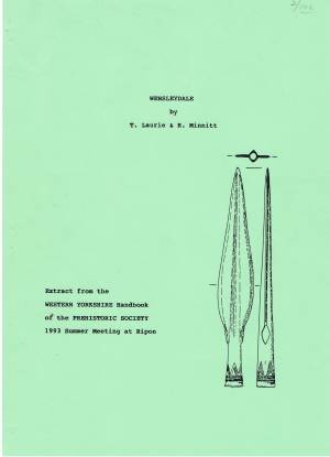 |
| Image 2 ID | 5302 Click image to enlarge |
| Image 2 Description | Addlebrough Hill. Summit cairn. The cup marked rocks were originally covered within the body of a much larger cairn subsequently reduced by quarrying for nearby drystone walls. The trig point has now been removed. | 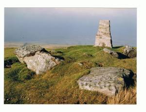 |
| Image 3 ID | 5303 Click image to enlarge |
| Image 3 Description | Addlebrough Hill. View westward over Wensleydale from the summit cairn. | 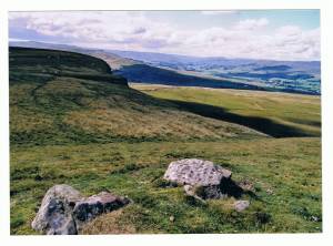 |
| Image 4 ID | 5283 Click image to enlarge |
| Image 4 Description | | 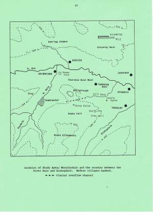 |
| Image 5 ID | 5284 Click image to enlarge |
| Image 5 Description | |  |
| Image 6 ID | 5285 Click image to enlarge |
| Image 6 Description | | 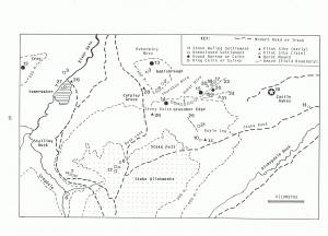 |
| Image 7 ID | 5286 Click image to enlarge |
| Image 7 Description | |  |
| Image 8 ID | 5287 Click image to enlarge |
| Image 8 Description | |  |
| Image 9 ID | 5288 Click image to enlarge |
| Image 9 Description | |  |
| Image 10 ID | 5289 Click image to enlarge |
| Image 10 Description | |  |
| Image 11 ID | 5290 Click image to enlarge |
| Image 11 Description | |  |
| Image 12 ID | 5291 Click image to enlarge |
| Image 12 Description | | 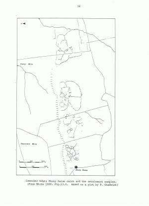 |
| Image 13 ID | 5292 Click image to enlarge |
| Image 13 Description | |  |
| Image 14 ID | 5293 Click image to enlarge |
| Image 14 Description | |  |
| Image 15 ID | 5294 Click image to enlarge |
| Image 15 Description | |  |
| Image 16 ID | 5295 Click image to enlarge |
| Image 16 Description | |  |
| Image 17 ID | 5296 Click image to enlarge |
| Image 17 Description | |  |
| Image 18 ID | 5297 Click image to enlarge |
| Image 18 Description | |  |
| Image 19 ID | 5298 Click image to enlarge |
| Image 19 Description | |  |
| Image 20 ID | 5299 Click image to enlarge |
| Image 20 Description | |  |
| Image 21 ID | 5300 Click image to enlarge |
| Image 21 Description | |  |
| Image 22 ID | 5301 Click image to enlarge |
| Image 22 Description | | 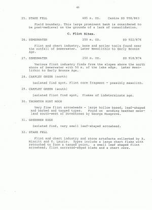 |