|
| *****SWAAG_ID***** | 67 |
| Date Entered | 12/01/2011 |
| Updated on | 05/01/2012 |
| Recorded by | Tim Laurie |
| Category | Burnt Mound |
| Record Type | Archaeology |
| Site Access | Private |
| Record Date | 01/01/2005 |
| Location | Thornton Rust Moor. Springs near Shooting Hut south of Dovestones |
| Civil Parish | Thornton Rust |
| Brit. National Grid | SD 965 874 |
| Altitude | 335m |
| Geology | Braided spring streams rising below Underset Limestone. |
| Record Name | Thornton Rust Moor SSSI. The Shooting Hut. Six burnt mounds by braided springs. |
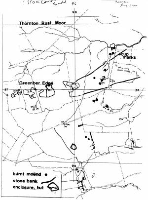
| Record Description | Thornton Rust Moor SSSI. See TCL Survey and Location Plan.
6 Burnt Mounds: All sites are on the banks of spring streams above and below the shooting hut, small stone rings nearby. Fine flint arrowheads ( See Laurie 2003, Figure 65, Nos 30-7)now in the Dales Countryside Museum, Hawes) found on slope South of shooting hut.
SD 965 874centre
|
| Dimensions | All medium, average* |
| Additional Notes | *Indicative Dimensions.
Size: Small <6m, Medium 6m-9m, Large 10m-15m, Extra large >15m.
Height: Low <0.5m, Average 0.5-1.0m, High >1.0m.
|
| Image 1 ID | 243 Click image to enlarge |
| Image 1 Description | Thornton Rust Moor.The Shooting Hut. Six burnt mounds located at these braided spring streams. |  |
| Image 2 ID | 1751 Click image to enlarge |
| Image 2 Description | Thornton Rust Moor. Location of Burnt Mounds at the Shooting Hut Springs and on Black Pasture. |  |
| Image 3 ID | 245 Click image to enlarge |
| Image 3 Description | Thornton Rust Moor.The Shooting Hut. One of Six burnt mounds |  |
| Image 4 ID | 246 Click image to enlarge |
| Image 4 Description | Thornton Rust Moor.The Shooting Hut. One of Six burnt mounds |  |
| Image 5 ID | 247 Click image to enlarge |
| Image 5 Description | Thornton Rust Moor.Sheepfold. Two burnt mounds here. |  |
| Image 6 ID | 244 Click image to enlarge |
| Image 6 Description | Thornton Rust Moor.The Shooting Hut. One of Six burnt mounds. |  |


