|
| *****SWAAG_ID***** | 649 |
| Date Entered | 04/12/2012 |
| Updated on | 04/12/2012 |
| Recorded by | Tim Laurie |
| Record Type | Archaeology |
| Site Access | Private |
| Record Date | 24/10/2010 |
| Location | Clapgate Plantation. |
| Civil Parish | Marske |
| Brit. National Grid | NZ 108 010 |
| Altitude | 190m |
| Geology | Boulder clay over Underset Limestone. |
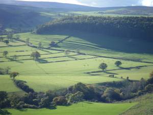
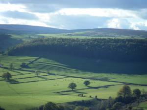
| Record Name | Cultivation terraces (strip lynchets) below Clapgate Plantation. |
| Record Description | Fine series of stepped cultivation terraces which as seen from the old scenic road from Richmond to Marske, are probably the most admired and among the least understood of all Swaledale archaeological landscapes. |
| Dimensions | See photographs. |
| Additional Notes | Strip lynchet cultivation terraces are difficult to date but are generally believed to have been in occupation during the medieval and post medieval periods. Their origins may however date as far as the Late Iron Age and to the period of the Roman Occupation. They may have been cultivated continuously or intermittently, with abandonment at times of stress.
There are early settlements in Clapgate which certainly date back to the Late Iron Age and to the period of the Roman Occupation. |
| Image 1 ID | 3778 Click image to enlarge |
| Image 1 Description | Cultivation terraces, strip lynchets photographed from West Applegarth. |  |
| Image 2 ID | 3779 Click image to enlarge |
| Image 2 Description | Cultivation terraces, strip lynchets photographed from West Applegarth. |  |

