|
First published in the 10th Anniversary
Edition (Issue 25) of "The Underground",
the Newsletter of the Bedale Archaeology and History Society, September
2009.

The Roman
fort at Brough-by-Bainbridge is both well-known and rather enigmatic. In
reply to the highly technical questions WHAT? WHERE?, WHEN?, WHO? and
WHY? we have fairly good answers - more than for many forts - to
everything except WHY?, and therein lies the enigma.
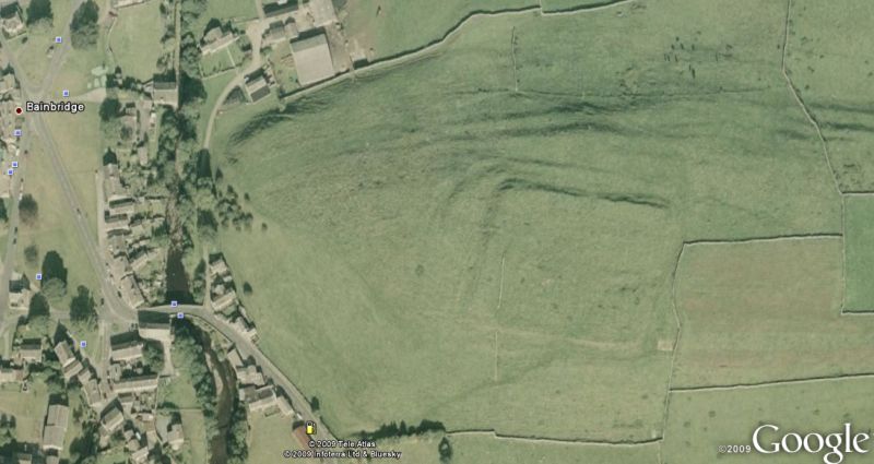
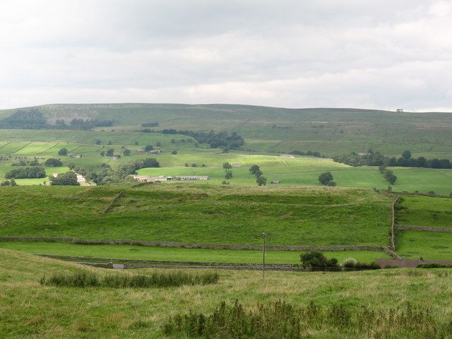
WHAT, WHERE and WHEN are easy. We can see the fort clearly – the classic
playing-card shape of a Roman fort on a large glacial moraine beside the
river Ure just east of Bainbridge, with the line of the Roman road
towards Burrow-in-Lonsdale (on the main West coast route from Chester to
Carlisle) marching South-West from the fort across the slopes of Wether
Fell (classified as No. 73 in Ivan Margary’s comprehensive survey of
Roman roads in Britain). William Camden in his “Britannia” (1586)
mentions it under the name Bracchium, a mis-interpretation of a now lost
inscription which persisted until changed in the Fourth edition of the
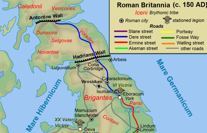
Ordnance Survey map of Roman Britain. We now know the fort as Virosidum
which may mean “the settlement by the Ure”. It is the right size at 2.5
acres to house up to 500 auxiliaries (the annex built in the early third
century added 1.8 acres). It has been repeatedly excavated by reputable
archaeologists, from the Yorkshire Archaeological Society under Dr J L
Kirk in 1925-26, supervised by the great R G Collingwood, through J P
Droop in1928-31 and W V Wade in 1950-53, to the excavations by Leeds
University from 1957-69 under Brian Hartley. We know from these digs
that the site was occupied more-or-less continuously by the Romans
during their time in the North of England, with the usual exceptions
around the time of the building of Hadrian’s Wall after the Emperor’s
visit to Britain in A.D. 122 (when all forts east of the Pennines appear
to have been emptied), and the advance into Scotland in the reign of
Antoninus Pius (138-161), when the forts on Hadrian’s Wall and many
others in the North were abandoned as their garrisons moved up to the
new line of the Antonine Wall in the 140's.

We know WHO was there for much of the time: the Sixth Cohort of Nervians,
a 500-strong auxiliary infantry unit from what is now Belgium, attested
at Bainbridge in inscriptions in stone (now lost) from the period
205-208, and in the “Notitia Dignitatum” which probably reflects army
dispositions in the late fourth century and lists this cohort at
Virosidum under the control of the Duke of the Provinces of Britain (who
was almost certainly based at York) commanded by a Tribune (i.e. a
legionary rather than a local officer). The unit is known to have been
in Britain in the 120s (from military diplomas), at Gt. Chesters on
Hadrian’s Wall, and at Rough Castle on the Antonine Wall in the 140s
where inscriptions show that it built the headquarters building. What we
do not know is whether it was an early arrival, perhaps stationed at
Bainbridge before moving up for wall-building under Hadrian, or whether
it came to Britain with him; nor whether it headed south again before
moving into Scotland in the 140s; nor whether it returned to Bainbridge
immediately thereafter.
But WHY? Why Bainbridge? In most maps of Roman fort sites in Northern
Britain, Bainbridge appears exceptional in its position and its
isolation. The maps, with the honourable exception of that in Robert
White’s “A Landscape Through Time”, show a substantial fort at the end
of a long road, more than a standard day’s march from anywhere else. It
is the only fort in North and Central Brigantia (shorthand I will use
for the lands occupied by the Brigantes, a group of tribes whose
territory stretched from the North Midlands to possibly north of the
Wall) which does not lie on the roads which dissect Brigantia in both
North-South and East-West directions. It is not near anywhere we know of
as a Brigantian stronghold, or on a main pre-Roman route.
But the Romans did not build cul-de-sacs. The alternative, hinted at by
Robert White’s map, is that Bainbridge stood where up to five Roman
roads met: South-West to Burrow-in-Lonsdale as already mentioned;
towards Elslack or Ilkley (Margary 730) on the Ribchester-York road; via
Mallerstang towards Brougham and via Askrigg, Swaledale and
Arkengarthdale to Bowes (both on the East-West Stainmoor road), and down
Wensleydale to Catterick. That in itself does not answer the question of
how far it is from other known, well-occupied forts: there may be sites
we are missing, like the ploughed-our remains at Wensley which were only
discovered through aerial photography in 1976. Or why it was so
continuously occupied while other forts were abandoned or civilianized.
If it was an important communications hub, or the Brigantes in the area
were seen as dangerous, why was it left empty at all? If the answer is
neither of the above, why was it occupied for so long?
To reach the WHY, we have to look at Bainbridge in the light of what we
know about where and why the Romans built forts. Forts were not
primarily defensive (although they were of course defensible.) They were
for offense, for control and for supervision. The cohort at Bainbridge –
around 500 full-time, trained professional soldiers – was almost
certainly larger and more competent than any force likely to be brought
against it. That is not to say that the Brigantes lacked good warriors,
or could not and did not assemble large war-bands. But if they did, they
surely deployed them against more important and lucrative targets. If
they had attacked and destroyed Bainbridge, the Romans had plenty of
other lines of defence and counter-attack.

The Romans
were great pragmatists, and abandoned forts quickly once they ceased to
serve the army’s purposes. So Bainbridge must have served strategic
rather than just tactical ends. But we know of no nearby Brigantian
centre to control and supervise, and chastise if necessary, and of no
major Brigantian lines of communication (which surely followed the hills
rather than the wooded, marshy valleys) best controlled from a hillock
in the Ure valley. The easy answer is that Bainbridge was a centre for
the control and supervision of lead-mining, a very important activity
for the Roman military and civil economy and one often subject to
imperial and military control (especially if mines were worked by
Brigantes enslaved after their revolt against Cartimandua in A.D. 69).
But the places where Roman or Roman-controlled mining can be
hypothesized could have been more easily controlled from elsewhere:
lower Wensleydale from Catterick, Arkengarthdale/Marrick/Hurst from
Bowes, Nidderdale and Wharfedale from the forts on the
Ribchester-Aldborough road.
So why Bainbridge? I put forward the following suggestions, all needing
to be tested. First, Bainbridge was founded as part of the occupation of
Brigantia, either in the early 70s when the Governor Petillius Cerialis
first attacked the Brigantes after his predecessor had rescued
Cartimandua by force from her rebellious kinsmen, or in the early 80s
when Agricola subdued the North and marched far into Scotland. It
oversaw a significant part of Brigantian territory at a time when the
Romans could no longer be sure of that Brigantian acquiescence which
they had enjoyed during Cartimandua’s reign. As things settled down,
Bainbridge proved to be useful. It continued to oversee a big chunk of
wild country. While not ideally placed, it was a good-enough place to
supervise economic activity in the area, including policing slaves in
the mines. There was enough agricultural land nearby to make it
relatively self-sufficient. Along five roads, it could provide
reinforcements in the event of trouble elsewhere: equally, it could be
easily reinforced from all those points. In a broader sense, it was a
useful place to hold soldiers in reserve and keep them busy: David
Breeze, the U.K.’s leading expert on Roman walls, barriers and
frontiers, has suggested precisely that role for many forts in Northern
England, not as a form of defence-in-depth but rather to hold a ready
reserve against trouble on the frontiers, because the size of forts on
Hadrian’s Wall, and the costly logistics of supplying many of them which
had no significant agricultural hinterland, imposed limits on the number
of troops which could be stationed directly on the Wall.
So, Bainbridge was useful. Its garrison was withdrawn for the Wall and
for Scotland. There is some evidence of other episodes of abandonment,
and of fire and demolition damage, but no more than elsewhere, and it is
not easy to distinguish accidental fires or deliberate demolition from
the results of enemy action. But each time the soldiers came back.
We must also remember that the garrison probably became increasingly
“embedded” as the years went by. Perhaps the Sixth Cohort of Nervians
recruited from their homeland in Belgium for some time after coming to
Bainbridge. Perhaps for many decades they were an occupying force,
brutal and violent as Roman soldiers could be, 500 aggressive males with
no law but their own, outnumbering local men wherever they went. But
over time, as ease of communication within the Empire deteriorated, as
liaisons with local women increased, as marriage rules for soldiers were
relaxed, and particularly once the Empire insisted that sons followed
their fathers’ vocation, the unit surely became more and more composed
of local men, with perhaps only a few senior officers from elsewhere. By
the mid-fourth century, the cohort (while still professional soldiers)
may have seemed more like a local defence force, integrated into the
community, its men retiring to family farms once they had served their
time. And so it surely continued, until one of the many usurpers from
Britain after A .D. 350 took the unit away to fight for Imperial power
on the continent. Or until the pay stopped coming after A. D. 400 and
the garrison simply slipped back into the local community, soldiers
still, after a fashion, but husbands, sons, farmers
and artisans as
well.----- -----
-----
Bainbridge Roman Fort has been scheduled by
English Heritage. Their report can be read
here.
|


