| Viewing swaag.org website implies consent to set cookies on your computer. Full details | Swaledale and
Arkengarthdale Archaeology Group Registered Charitable Incorporated Organisation Number 1155775 |
SWAAG Honorary President:
Tim Laurie F,S,A, |
| SWAAG News Archive | |
| News Archive | |
| A Walk to Maiden Castle | |
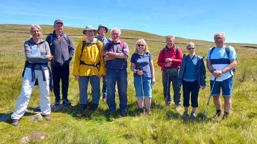
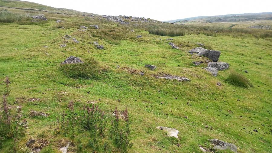
| On Sunday 10th July, six members and two guests joined Judith and Alan Mills for the short walk to the Roman fortlet, Maiden Castle, perched up above the A66 overlooking the Eden Valley. John Nolan of the Northumberland Archaeology Group joined us; many members will remember John and his partner Jenny Vaughan helping us with the Big Dig. It was extremely useful to have John along; as a professional archaeologist he pointed out much which might otherwise have passed us by. Having left Swaledale on a beautifully warm and sunny morning, about 18C, we were rather surprised to find that our meeting point and the fortlet were in low cloud, with a chilly wind, about 12C. Rummaging around in our cars found sufficient kit to keep everyone warm although Alan ended up wearing an old bright yellow oilskin, kept in the car for emergencies. The walk began by going up what looked suspiciously like a Roman road complete with what looked like an ‘agger’, ditches either side. Later after seeing much evidence of quarrying up above the consensus was that it was a more modern track to cart stone down into the valley, possibly for walling or maybe for the nearby Stainmore railway line. After a short climb up this track, onto the plateau, the actual Roman road is met running broadly East-West; this connected the Roman military strongholds of York and Carlisle. The A66 mainly follows the line of this road. Along the road are some small orthostats which might have been road markers of some sort, with any inscription long gone. Maiden Castle is about one kilometre north-west along the old Roman road although a detour is called for to avoid a rather boggy section. The fort comes into view sitting up above the Eden valley below. Previous excavations of this now scheduled ancient monument show that it was occupied from at least the early 2nd C to the late 4th. On our visits, the archaeologists’ friends aka rabbits, have uncovered Roman pottery in the area with small enclosures to the south-west (see plan below); possibly cultivation or maybe some house platforms. Previously we found a piece of grey-ware and part of a Crambeck ware mortarium and on this visit a piece of grey-ware pot rim. Maiden Castle is an interesting fort in an interesting position. It seems to be part of a network of Roman works including the Roman road itself (its route mainly followed by the A66), the forts at Greta Bridge, Bowes and Brough, the marching camps at Rokeby Park, Rey Cross and Crackenthorpe and a number of possible signal stations. Why is the fort such a small fort there? It is very small, about 40 x 50 metres internally; perhaps just about enough to accommodate a ‘century’ of 80-100 soldiers. Perhaps a clue lies in a small flat area just outside the fort walls in the south-west corner. This might possibly have been the platform for a signal station. Maybe the fort was there to defend the signal stations in the area, react to any identified threats? We left Maiden Castle in bright warm sunshine, with perhaps more questions than when we arrived. Maybe a topic for a future talk. Our thanks to Hilary Fawcett and Lesley Wolsey for taking the photographs. Judith and Alan Mills July 2022 |
|
 |
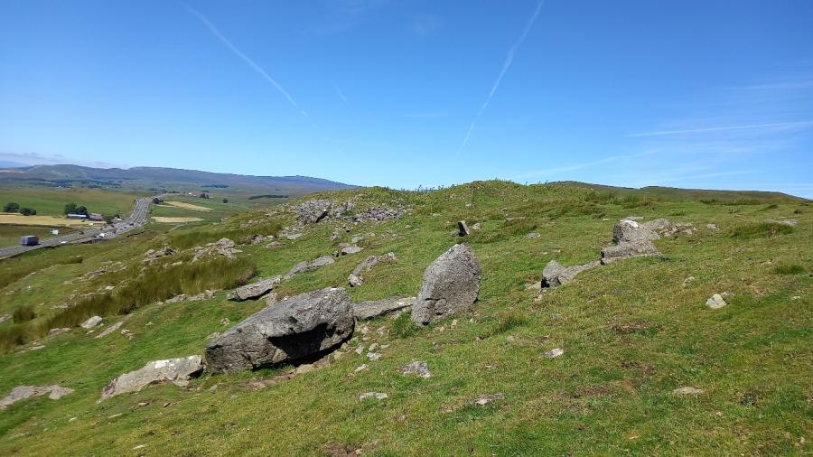 |
| The faint ‘con trails’ in the sky point to the fort’s east entrance | |
| Click Images to Enlarge | |
 |
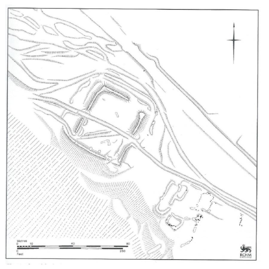 |
| An enclosure or house platform? | Plan of Maiden Castle Roman fortlet © RCHME 1963 |
| News Record: 158 Updated: 27-07-2022 12:58:28 | |