|
Swaledale and Arkengarthdale Archaeology Group The Swaledale Project 7000 Years of a Landscape and its People Registered Charitable Incorporated Organisation Number 1155775 |
The Swaledale Project: Bellerby Moor SAR Survey
The Ministry of Defence (MOD) have received permission to construct a new electronic target range close to the existing ranges on Bellerby Moor. During the planning process an Impact Assessment requirement suggested SWAAG could undertake an archaeological landscape survey of the proposed site, with the possibility of being involved in the any archaeological ground investigation that may follow.
The tight time scale and the limited availability for site access required designated SWAAG members to do the survey, but a day was organised for members to view the landscape prior to further involvement that may follow.
MOD planning for the range has tried to minimise the impact of the range footprint on the known archaeological features identified by an earlier walkover survey. The earthwork construction inside the footprint will have an impact on archaeological features; thereby requiring a number of archaeology and other features to be assessed and possibly excavated.
An appreciation of this site and the surrounding area has been recorded by Tim Laurie and can be read here.
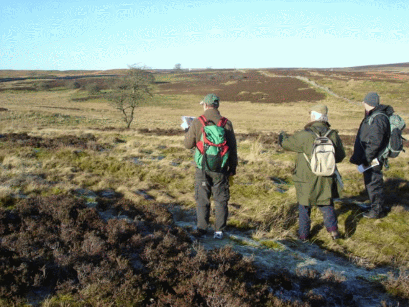
Looking across the southern end of the propose Small Arms Range
on Bellerby Moor.
Photo: Gill Savage.
The survey report is detailed below: Click the maps to see them at best resolution.
| Swaledale and Arkengarthdale Archaeology
Group Contact info@swaag.org Website http://www.swaag.org/ |
||||||||||||||||||||||||||||||||||||||||||||||||||||||||||||||||||||||||||||||||||||||||||||||||||||||||||||||||||||||||||||||||||||||||||||||||||||||||||||||||||||||||||||||||||||||||||||||||||||||||
Report on an earthwork survey in advance of the construction of a new electronic target range at Bellerby Moor, North Yorkshire, with reference to paragraph 5.4 of the Archaeological Impact Statement and Recommendation for Archaeological Investigation by Phil Abramson, DIO Historic Environment Advisor (Catterick), December 2011. The Swaledale and Arkengarthdale Archaeology Group (SWAAG) surveyed the site of the proposed new range at Bellerby Moor and the immediate vicinity between 14th and 16th January2012. The survey conditions were difficult in areas of substantial heather and rushes. It is therefore possible that archaeological important sites have been missed. Thirty six features were identified and whilst not all are directly relevant to the construction footprint, they do indicate the archaeological and geological context and importance of the range footprint on Bellerby Moor, and support the further investigation of the features that will be impacted by the construction. There are a number of features close to the range footprint that must be protected. |
||||||||||||||||||||||||||||||||||||||||||||||||||||||||||||||||||||||||||||||||||||||||||||||||||||||||||||||||||||||||||||||||||||||||||||||||||||||||||||||||||||||||||||||||||||||||||||||||||||||||
 |
||||||||||||||||||||||||||||||||||||||||||||||||||||||||||||||||||||||||||||||||||||||||||||||||||||||||||||||||||||||||||||||||||||||||||||||||||||||||||||||||||||||||||||||||||||||||||||||||||||||||
|
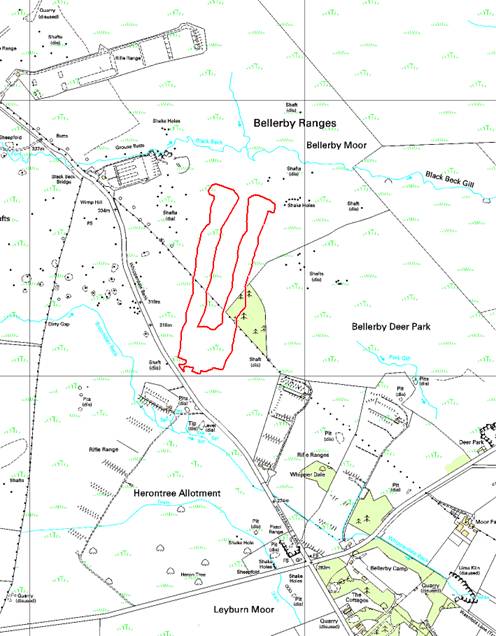
Ordnance Survey 1:10,000 maps: © Crown copyright and database
rights 2011 Ordnance Survey 100023740, kindly supplied by the
North Yorkshire Dales National Park Authority. |
||||||||||||||||||||||||||||||||||||||||||||||||||||||||||||||||||||||||||||||||||||||||||||||||||||||||||||||||||||||||||||||||||||||||||||||||||||||||||||||||||||||||||||||||||||||||||||||||||||||||
Report Contents: 1) Gazetteer of Features 2) Map 1 Summary map indicating the location of features in the area surveyed. 3) Map 2 Small Arms Range Southern Section - wide view. 4) Map 3 Small Arms Range Southern Section - detailed view of range footprint. 5) Map 4 Small Arms Range Central Section. 6) Map 5 Small Arms Range Northern Section. 7) Map 6 Small Arms Range Northern Section Braided Trackway Margins. Gazetteer of Features: Site marked by ** are on, between or close to the outer edge of Small Arms Range footprint. |
||||||||||||||||||||||||||||||||||||||||||||||||||||||||||||||||||||||||||||||||||||||||||||||||||||||||||||||||||||||||||||||||||||||||||||||||||||||||||||||||||||||||||||||||||||||||||||||||||||||||
|
||||||||||||||||||||||||||||||||||||||||||||||||||||||||||||||||||||||||||||||||||||||||||||||||||||||||||||||||||||||||||||||||||||||||||||||||||||||||||||||||||||||||||||||||||||||||||||||||||||||||
|
Report prepared by: Tim Laurie and Stephen Eastmead. ©Swaledale and Arkengarthdale Archaeology Group. January 27/01/2012. |
||||||||||||||||||||||||||||||||||||||||||||||||||||||||||||||||||||||||||||||||||||||||||||||||||||||||||||||||||||||||||||||||||||||||||||||||||||||||||||||||||||||||||||||||||||||||||||||||||||||||
Map1 - Click to enlarge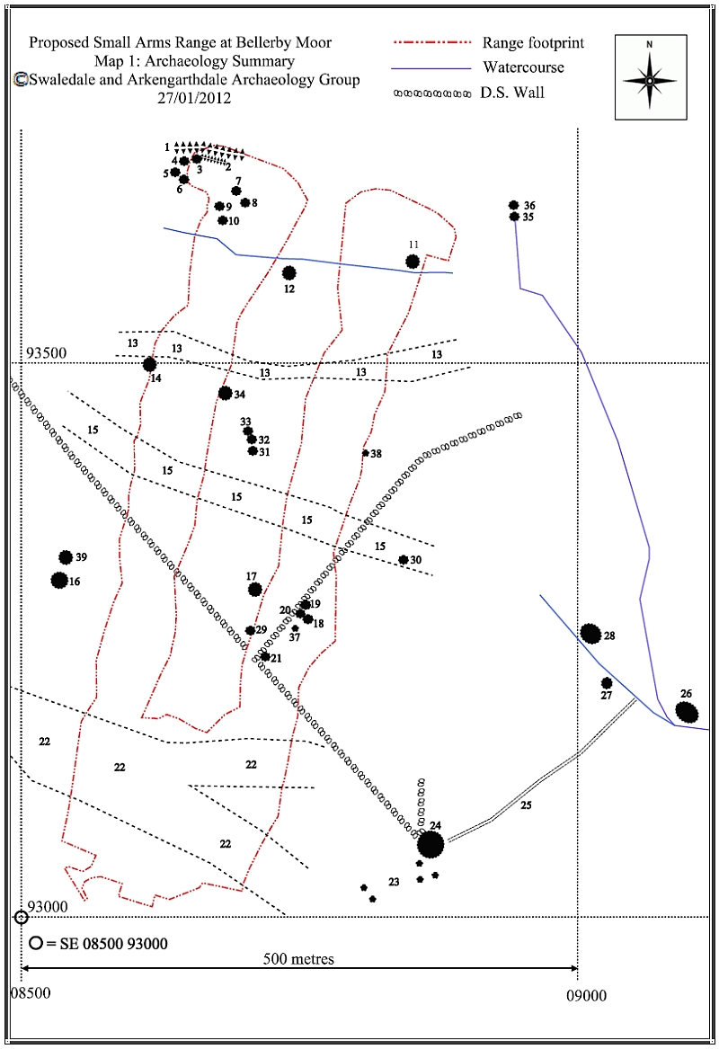 |
||||||||||||||||||||||||||||||||||||||||||||||||||||||||||||||||||||||||||||||||||||||||||||||||||||||||||||||||||||||||||||||||||||||||||||||||||||||||||||||||||||||||||||||||||||||||||||||||||||||||
Map2 - Click to enlarge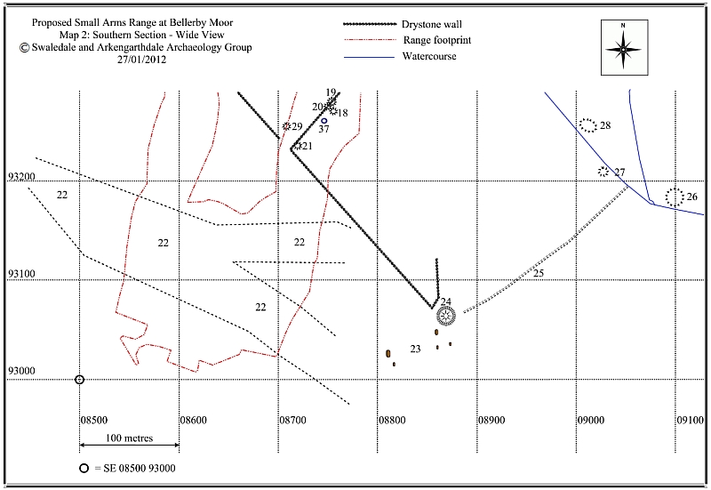 |
||||||||||||||||||||||||||||||||||||||||||||||||||||||||||||||||||||||||||||||||||||||||||||||||||||||||||||||||||||||||||||||||||||||||||||||||||||||||||||||||||||||||||||||||||||||||||||||||||||||||
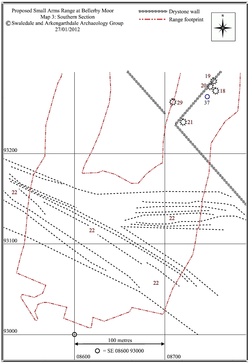
| Map3 - Click to enlarge | ||||||||||||||||||||||||||||||||||||||||||||||||||||||||||||||||||||||||||||||||||||||||||||||||||||||||||||||||||||||||||||||||||||||||||||||||||||||||||||||||||||||||||||||||||||||||||||||||||||||||
 |
||||||||||||||||||||||||||||||||||||||||||||||||||||||||||||||||||||||||||||||||||||||||||||||||||||||||||||||||||||||||||||||||||||||||||||||||||||||||||||||||||||||||||||||||||||||||||||||||||||||||
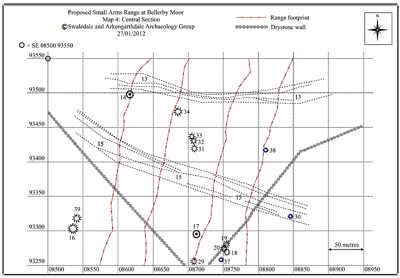
| Map4 - Click to enlarge | ||||||||||||||||||||||||||||||||||||||||||||||||||||||||||||||||||||||||||||||||||||||||||||||||||||||||||||||||||||||||||||||||||||||||||||||||||||||||||||||||||||||||||||||||||||||||||||||||||||||||
 |
||||||||||||||||||||||||||||||||||||||||||||||||||||||||||||||||||||||||||||||||||||||||||||||||||||||||||||||||||||||||||||||||||||||||||||||||||||||||||||||||||||||||||||||||||||||||||||||||||||||||
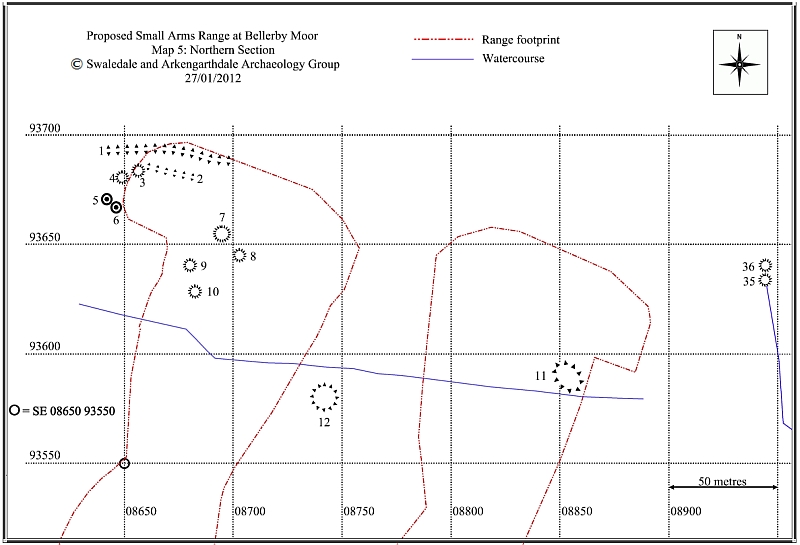
| Map5 - Click to enlarge | ||||||||||||||||||||||||||||||||||||||||||||||||||||||||||||||||||||||||||||||||||||||||||||||||||||||||||||||||||||||||||||||||||||||||||||||||||||||||||||||||||||||||||||||||||||||||||||||||||||||||
 |
||||||||||||||||||||||||||||||||||||||||||||||||||||||||||||||||||||||||||||||||||||||||||||||||||||||||||||||||||||||||||||||||||||||||||||||||||||||||||||||||||||||||||||||||||||||||||||||||||||||||
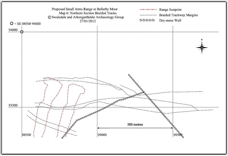
| Map6 - Click to enlarge | ||||||||||||||||||||||||||||||||||||||||||||||||||||||||||||||||||||||||||||||||||||||||||||||||||||||||||||||||||||||||||||||||||||||||||||||||||||||||||||||||||||||||||||||||||||||||||||||||||||||||
 |
||||||||||||||||||||||||||||||||||||||||||||||||||||||||||||||||||||||||||||||||||||||||||||||||||||||||||||||||||||||||||||||||||||||||||||||||||||||||||||||||||||||||||||||||||||||||||||||||||||||||
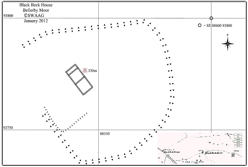
| Map7 - Click to enlarge Black Beck House was near to; but not part of the above survey. More data is available here. | ||||||||||||||||||||||||||||||||||||||||||||||||||||||||||||||||||||||||||||||||||||||||||||||||||||||||||||||||||||||||||||||||||||||||||||||||||||||||||||||||||||||||||||||||||||||||||||||||||||||||
 |