| The swaag.org website uses cookies to provide website use and other information. Full details | Swaledale and
Arkengarthdale Archaeology Group Swaledale Geology Pages © John Russell |
SWAAG Honorary President:
Tim Laurie FSA |
The Base of the Carboniferous Limestone
Text &
Images © John Russell 2011
|
Location: Arcow Quarry Grid Ref: OL2 803 706
Camera Direction: NW Click Images to enlarge
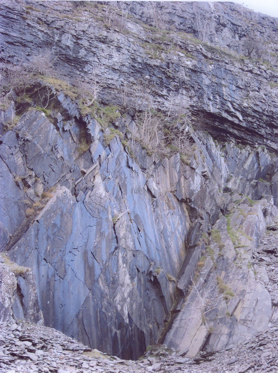
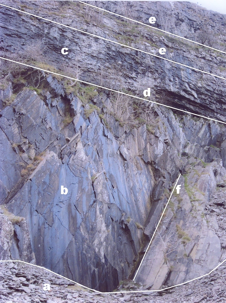
The rocks of Swaledale belong to the Carboniferous Period 354-290 million years ago. Carboniferous is derived from the Latin word carbo meaning coal. We will aim to look at all of the rocks of the Carboniferous. In doing so we’ll encounter our first problem and find that not all rocks of the Carboniferous outcrop on the surface in Swaledale. We cannot look at the geology of Swaledale in isolation, so other Pennine Dales will be visited to give a better understanding of Swaledale’s geology. The Carboniferous Period spans more than 60 million years. During this period of time, in evolutionary terms, plant and animal life exploded onto the land from the sea. Sixty million years is a vast period of time. To put this into context, we need to go back from the present day to the time, sixty million years when the last of the Dinosaurs would have been roaming over Swaledale. The Jurassic and Cretaceous rocks that once covered the Pennines in a huge arch have been removed by erosion, so that there is no trace of them today. The northern dales of Swaledale, Wensleydale, Wharfedale and Uredale have remarkably similar geological histories. They are dominated by carboniferous limestone, sandstone and shale. There is a huge gap in time and the next most recent features in Swaledale are caused by two million years of glaciations. The geology of the Dale will be developed through the medium of photographs. Photograph 1. Arcow Quarry. Grid Ref: 803 706. Direction: NW. Map OL2 The start of the Carboniferous is not seen in Swaledale due to the tilting of the whole of the Askrigg Block to the north at a low angle. The base of the Carboniferous can be found in southern areas of the region e.g. Thornton Force (OL2 695 754) and White Scar Caves (OL 716 746). The photograph of Arcow Quarry reveals the following features marked a) – f): a) shows the rocks mined at Arcow Quarry. These rocks were mined for road stone. b) shows Silurian rocks that are very hard, metamorphosed (changed by heat and pressure) greywackes, slates and grits found in the sea. A greywacke is a rock made of sand grains and gravel particles in a fine grained matrix of fine clay and silt particles. It has been used as road stone due to its very hard nature. Locally, it has been used in house building and dry stone walls. c) These rocks are part of the Great Scar Limestone and are some of the first Lower Carboniferous rocks on the Alston Block. They are sedimentary rocks deposited in warm tropical seas. Continental drift carried our country to latitude of around 20 degrees south. Notice the rocks are almost horizontal. The rocks at b) are tilted (dip) at a very high angle. The lines marked on e) and e1) are bedding planes separating the rock strata. The rocks on e1) are younger than those at e) because they lie on top of them. d) shows a ‘line’ that is known as an unconformity. The rocks at b) have an age of around 420 million years and those at c) have an age of 350 million years. The rocks at b) were compressed, folded and lifted out of the sea as two continents’ collided. They then suffered erosion for millions of years, right through the Devonian period. At the start of the Carboniferous the sea flooded in from the south and created the limestone of c) in warm tropical seas. Between these two rocks it is possible to find the remains of beaches. These can be seen at Thornton Force, under the lip of the waterfall. e) shows bedding planes. These are the lines between strata. f) shows the high angle of dip of the rocks; a result of continental collision during the Caledonian Orogery (a mountain building period). The unconformity seen in the photograph cannot be seen outcropping in Swaledale but it is there, underground. It marks the beginning of the Carboniferous in Swaledale and the spread of tropical seas over the Askrigg Block. |
|||||