|
| *****SWAAG_ID***** | 587 |
| Date Entered | 28/07/2012 |
| Updated on | 28/07/2012 |
| Recorded by | Tim Laurie |
| Category | Burnt Mound |
| Record Type | Archaeology |
| SWAAG Site Name | |
| Site Type | |
| Site Name | |
| Site Description | |
| Site Access | Public Access Land |
| Record Date | 01/01/2005 |
| Location | Askrig. Broomber. Below Coombs. |
| Civil Parish | Askrigg |
| Brit. National Grid | SD 971 915 |
| Altitude | 360m |
| Geology | Spring rise below the Middle Limestone. |
| Record Name | Askrig. Broomber. The |Coombs. Burnt mound Site 1. |
| Record Description | Very large burnt mound in gorse infested pasture at spring rise.
A second burnt mound has been recognised higher up on Broomber and this is to be recorded seperately as Site 2.
Round house settlement (unsurveyed) above this site. |
| Dimensions | 12m dia estimated and 1.2m high above present ground level. |
| Geographical area | |
| Species | |
| Scientific Name | |
| Common / Notable Species | |
| Tree and / or Stem Girth | |
| Tree: Position / Form / Status | |
| Tree Site ID | 0 |
| Associated Site SWAAG ID | 0 |
| Additional Notes | |
| Image 1 ID | 3188 Click image to enlarge |
| Image 1 Description | Askrig. Broomber. The |Coombs. Burnt mound Site 1. | 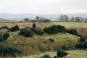 |
